Xinhe geodata
Xinhe (Hunan) is a seat of a fourth-order administrative division; located in China in Asia/Shanghai (GMT+8) time zone. In our database, there are 1268 cities with bigger population. Compared to other cities in China, 60.5% of cities are located further ↑North; 60% of cities are located further →East and 79.3% of cities have higher elevation than Xinhe. Note1


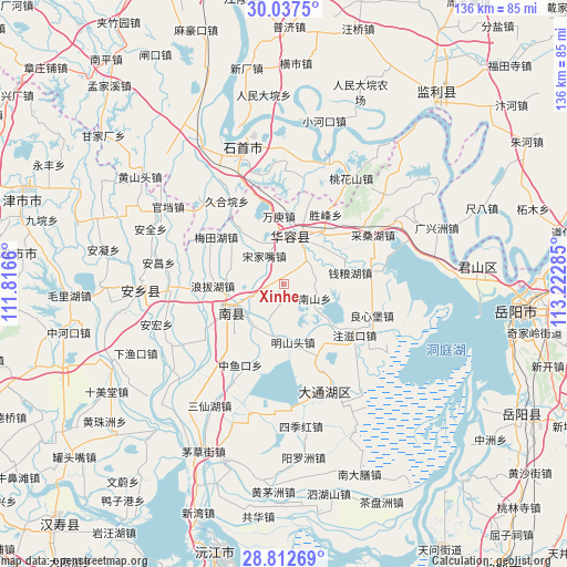
Xinhe GPS coordinates[2]
29° 25' 36.984" North, 112° 31' 10.992" East
| Map corner | latitude | longitude |
|---|---|---|
| Upper-left | 30.0375°, | 111.8166° |
| Center: | 29.42694°, | 112.51972° |
| Lower-right: | 28.81269°, | 113.22285° |
| Map W x H: | 136.2×136.2 km | = 84.6×84.6mi |
| max Lat: | 53.31946° ⇑60.5% North |
| Xinhe: | 29.42694° |
| min Lat: | ⇓39.5% South 18.22056° |
| min Long | Xinhe | max Long |
| 75.07348° | 112.51972° | 134.28917° |
| W 40%⇐ | ⇒60% E |
Elevation
Elevation of Xinhe is 28 m = 92 ft, and this is 456.8 m = 1499 ft below average elevation for this country.
| Max E: |
5622 m = 18445 ft | 79.3% |
| Avg. | 484.8 m = 1591 ft | |
| Xinhe | 28 m = 92 ft | |
Min E: |
-3 m = -10 ft | 20.7% |
See also: China elevation on elevation.city.
Geographical zone
Xinhe is located in North temperate zone (between Tropic of Cancer and the Arctic Circle). Distance of this Northern Tropic circle is 666.1 km =413.9 mi to South.| Distance of | km | miles | from Xinhe |
|---|---|---|---|
| North Pole | 6735.1 | 4185 | to North |
| Arctic Circle | 4129.2 | 2565.8 | to North |
| Tropic Cancer | 666.1 | 413.9 | to South |
| Equator | 3272 | 2033.1 | to South |


Nearby cities:
15 places around Xinhe: (largest is in red/bold)
• Beizhouzi
33.3 km =20.7 mi,  150°
150°
• Diaoguan
31.2 km =19.4 mi,  19°
19°
• Dongsheng
32.2 km =20 mi,  0°
0°
• Gaojimiao
25.6 km =15.9 mi,  339°
339°
• Huage
19.7 km =12.2 mi,  136°
136°
• Huarong Chengguanzhen
10.6 km =6.6 mi, 15°
• Jiaoshanhe
25.9 km =16.1 mi,  9°
9°
• Jiuheyuan
24.1 km =15 mi,  325°
325°
• Mahekou
27.2 km =16.9 mi,  238°
238°
• Meitianhu
18.7 km =11.6 mi,  305°
305°
• Nanzhou
13.6 km =8.5 mi, 236°
• Taohuashan
30.1 km =18.7 mi,  32°
32°
• Tuanshansi
27.9 km =17.3 mi,  315°
315°
• Tuanzhou
26.6 km =16.5 mi,  113°
113°
• Xiulin
34.2 km =21.3 mi, 340°
Sources, notices
• [Note1] Compared only with cities in China existing in our database
• [Src1] Map data: © OpenStreetMap contributors (CC-BY-SA)
• [Src2] Other city data from geonames.org with taken over terms of usage.
• [Src3] Geographical zone / Annual Mean Temperature by Robert A. Rohde @ Wikipedia
