Mabugang geodata
Mabugang (Guangdong) is a seat of a fourth-order administrative division; located in China in Asia/Shanghai (GMT+8) time zone. In our database, there are 1268 cities with bigger population. Compared to other cities in China, 88.2% of cities are located further ↑North; 56.5% of cities are located further ←West and 59.1% of cities have lower elevation than Mabugang. Note1


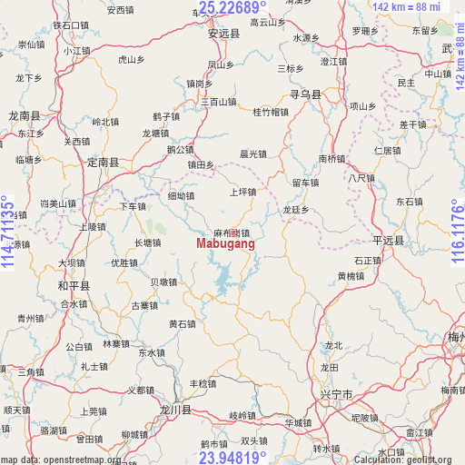
Mabugang GPS coordinates[2]
24° 35' 21.012" North, 115° 24' 52.092" East
| Map corner | latitude | longitude |
|---|---|---|
| Upper-left | 25.22689°, | 114.71135° |
| Center: | 24.58917°, | 115.41447° |
| Lower-right: | 23.94819°, | 116.1176° |
| Map W x H: | 142.2×142.2 km | = 88.4×88.4mi |
| max Lat: | 53.31946° ⇑88.2% North |
| Mabugang: | 24.58917° |
| min Lat: | ⇓11.8% South 18.22056° |
| min Long | Mabugang | max Long |
| 75.07348° | 115.41447° | 134.28917° |
| W 56.5%⇐ | ⇒43.5% E |
Elevation
Elevation of Mabugang is 248 m = 814 ft, and this is 236.8 m = 777 ft below average elevation for this country.
| Max E: |
5622 m = 18445 ft | 40.9% |
| Avg. | 484.8 m = 1591 ft | |
| Mabugang | 248 m = 814 ft | |
Min E: |
-3 m = -10 ft | 59.1% |
See also: China elevation on elevation.city.
Geographical zone
Mabugang is located in North temperate zone (between Tropic of Cancer and the Arctic Circle). Distance of this Northern Tropic circle is 128.1 km =79.6 mi to South.| Distance of | km | miles | from Mabugang |
|---|---|---|---|
| North Pole | 7273 | 4519.2 | to North |
| Arctic Circle | 4667.1 | 2900 | to North |
| Tropic Cancer | 128.1 | 79.6 | to South |
| Equator | 2734.1 | 1698.9 | to South |


Nearby cities:
15 places around Mabugang: (largest is in red/bold)
• Beidun
25.3 km =15.7 mi,  234°
234°
• Beiling
7.7 km =4.8 mi,  275°
275°
• Changpu
20.2 km =12.6 mi,  32°
32°
• Chenguang
25.1 km =15.6 mi,  14°
14°
• Chetian
21.6 km =13.4 mi,  216°
216°
• Chiguang
22.7 km =14.1 mi,  175°
175°
• Huilong
26.8 km =16.7 mi,  155°
155°
• Liuche
27.2 km =16.9 mi,  55°
55°
• Longting
20.7 km =12.9 mi,  69°
69°
• Luofu
18 km =11.2 mi,  112°
112°
• Shangping
13.1 km =8.1 mi, 14°
• Xintian
18.1 km =11.2 mi,  144°
144°
• Xi’ao
19.1 km =11.9 mi,  306°
306°
• Yanzhen
11.7 km =7.3 mi, 161°
• Zhentian
23.1 km =14.4 mi,  335°
335°
Sources, notices
• [Note1] Compared only with cities in China existing in our database
• [Src1] Map data: © OpenStreetMap contributors (CC-BY-SA)
• [Src2] Other city data from geonames.org with taken over terms of usage.
• [Src3] Geographical zone / Annual Mean Temperature by Robert A. Rohde @ Wikipedia
