Yanzhen geodata
Yanzhen (Guangdong) is a seat of a fourth-order administrative division; located in China in Asia/Shanghai (GMT+8) time zone. In our database, there are 1268 cities with bigger population. Compared to other cities in China, 88.5% of cities are located further ↑North; 56.7% of cities are located further ←West and 53.6% of cities have lower elevation than Yanzhen. Note1


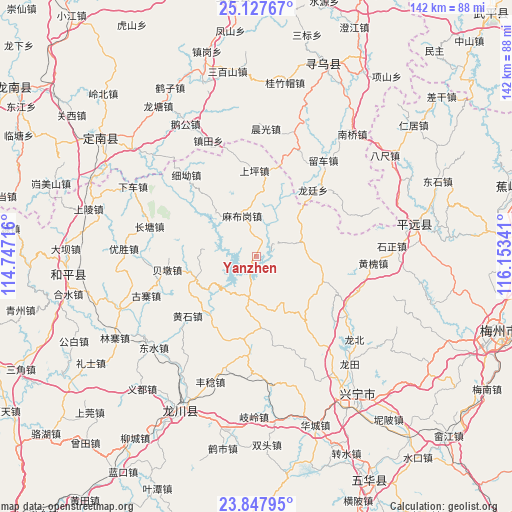
Yanzhen GPS coordinates[2]
24° 29' 21.984" North, 115° 27' 1.008" East
| Map corner | latitude | longitude |
|---|---|---|
| Upper-left | 25.12767°, | 114.74716° |
| Center: | 24.48944°, | 115.45028° |
| Lower-right: | 23.84795°, | 116.15341° |
| Map W x H: | 142.3×142.3 km | = 88.4×88.4mi |
| max Lat: | 53.31946° ⇑88.5% North |
| Yanzhen: | 24.48944° |
| min Lat: | ⇓11.5% South 18.22056° |
| min Long | Yanzhen | max Long |
| 75.07348° | 115.45028° | 134.28917° |
| W 56.7%⇐ | ⇒43.3% E |
Elevation
Elevation of Yanzhen is 194 m = 636 ft, and this is 290.8 m = 954 ft below average elevation for this country.
| Max E: |
5622 m = 18445 ft | 46.4% |
| Avg. | 484.8 m = 1591 ft | |
| Yanzhen | 194 m = 636 ft | |
Min E: |
-3 m = -10 ft | 53.6% |
See also: China elevation on elevation.city.
Geographical zone
Yanzhen is located in North temperate zone (between Tropic of Cancer and the Arctic Circle). Distance of this Northern Tropic circle is 117.1 km =72.8 mi to South.| Distance of | km | miles | from Yanzhen |
|---|---|---|---|
| North Pole | 7284.1 | 4526.1 | to North |
| Arctic Circle | 4678.2 | 2906.9 | to North |
| Tropic Cancer | 117.1 | 72.8 | to South |
| Equator | 2723 | 1692 | to South |


Nearby cities:
15 places around Yanzhen: (largest is in red/bold)
• Beidun
24.4 km =15.2 mi,  261°
261°
• Beiling
16.4 km =10.2 mi,  316°
316°
• Chetian
17.7 km =11 mi,  249°
249°
• Chiguang
11.7 km =7.3 mi,  189°
189°
• Daping
22.2 km =13.8 mi,  144°
144°
• Huangshi
25.2 km =15.7 mi,  228°
228°
• Huilong
15.3 km =9.5 mi,  150°
150°
• Lizui
20.2 km =12.6 mi,  217°
217°
• Longmu
25.2 km =15.7 mi,  183°
183°
• Longting
24.2 km =15 mi,  40°
40°
• Luofu
13.7 km =8.5 mi,  72°
72°
• Luogang
19.5 km =12.1 mi,  111°
111°
• Mabugang
11.7 km =7.3 mi,  341°
341°
• Shangping
23.8 km =14.8 mi,  358°
358°
• Xintian
7.9 km =4.9 mi,  117°
117°
Sources, notices
• [Note1] Compared only with cities in China existing in our database
• [Src1] Map data: © OpenStreetMap contributors (CC-BY-SA)
• [Src2] Other city data from geonames.org with taken over terms of usage.
• [Src3] Geographical zone / Annual Mean Temperature by Robert A. Rohde @ Wikipedia
