Linkou geodata
Linkou (Hunan) is a populated place; located in China in Asia/Shanghai (GMT+8) time zone. With population of 2,270 people, there are 1004 cities with bigger population in this country. Compared to other cities in China, 81.4% of cities are located further ↑North; 71.9% of cities are located further →East and 69.2% of cities have lower elevation than Linkou. Note1


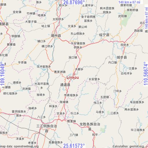
Linkou GPS coordinates[2]
26° 14' 53.016" North, 109° 51' 48.996" East
| Map corner | latitude | longitude |
|---|---|---|
| Upper-left | 26.87696°, | 109.16049° |
| Center: | 26.24806°, | 109.86361° |
| Lower-right: | 25.61573°, | 110.56674° |
| Map W x H: | 140.2×140.2 km | = 87.1×87.1mi |
| max Lat: | 53.31946° ⇑81.4% North |
| Linkou: | 26.24806° |
| min Lat: | ⇓18.6% South 18.22056° |
| min Long | Linkou | max Long |
| 75.07348° | 109.86361° | 134.28917° |
| W 28.1%⇐ | ⇒71.9% E |
Elevation
Elevation of Linkou is 396 m = 1299 ft, and this is 88.8 m = 291 ft below average elevation for this country.
| Max E: |
5622 m = 18445 ft | 30.8% |
| Avg. | 484.8 m = 1591 ft | |
| Linkou | 396 m = 1299 ft | |
Min E: |
-3 m = -10 ft | 69.2% |
See also: China elevation on elevation.city.
Geographical zone
Linkou is located in North temperate zone (between Tropic of Cancer and the Arctic Circle). Distance of this Northern Tropic circle is 312.6 km =194.2 mi to South.| Distance of | km | miles | from Linkou |
|---|---|---|---|
| North Pole | 7088.6 | 4404.7 | to North |
| Arctic Circle | 4482.7 | 2785.4 | to North |
| Tropic Cancer | 312.6 | 194.2 | to South |
| Equator | 2918.5 | 1813.5 | to South |


Nearby cities:
15 places around Linkou: (largest is in red/bold)
• Boyang
34.5 km =21.4 mi,  263°
263°
• Chang’anying
22.6 km =14 mi,  85°
85°
• Dankou
39.8 km =24.7 mi,  71°
71°
• Diyangping
26.1 km =16.2 mi,  275°
275°
• Dongshan Dongzuxiang
38.7 km =24 mi,  4°
4°
• Jiangtousi
33.4 km =20.8 mi,  112°
112°
• Le’anpu Miaozudongzuxiang
27.7 km =17.2 mi,  8°
8°
• Longcheng
25.3 km =15.7 mi,  199°
199°
• Pukou
43.2 km =26.8 mi,  314°
314°
• Quyang
42.7 km =26.5 mi,  328°
328°
• Rulin
41.6 km =25.8 mi, 74°
• Shuangjiang
18.2 km =11.3 mi,  235°
235°
• Xianxi
24 km =14.9 mi,  293°
293°
• Yatunpu
25.8 km =16 mi,  246°
246°
• Zhaishi Miaozu Dongzuxiang
33.4 km =20.8 mi,  32°
32°
Sources, notices
• [Note1] Compared only with cities in China existing in our database
• [Src1] Map data: © OpenStreetMap contributors (CC-BY-SA)
• [Src2] Other city data from geonames.org with taken over terms of usage.
• [Src3] Geographical zone / Annual Mean Temperature by Robert A. Rohde @ Wikipedia
