Chang’anying geodata
Chang’anying (Hunan) is a populated place; located in China in Asia/Shanghai (GMT+8) time zone. With population of 880 people, there are 1202 cities with bigger population in this country. Compared to other cities in China, 81.3% of cities are located further ↑North; 70.8% of cities are located further →East and 83.3% of cities have lower elevation than Chang’anying. Note1


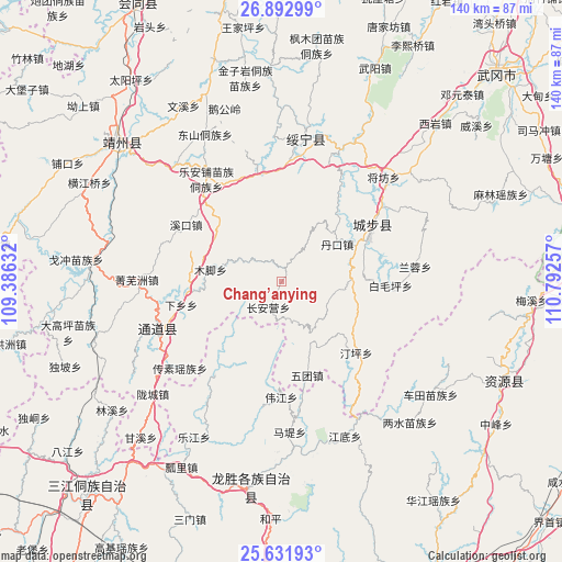
Chang’anying GPS coordinates[2]
26° 15' 51.012" North, 110° 5' 21.984" East
| Map corner | latitude | longitude |
|---|---|---|
| Upper-left | 26.89299°, | 109.38632° |
| Center: | 26.26417°, | 110.08944° |
| Lower-right: | 25.63193°, | 110.79257° |
| Map W x H: | 140.2×140.2 km | = 87.1×87.1mi |
| max Lat: | 53.31946° ⇑81.3% North |
| Chang’anying: | 26.26417° |
| min Lat: | ⇓18.7% South 18.22056° |
| min Long | Chang’anying | max Long |
| 75.07348° | 110.08944° | 134.28917° |
| W 29.2%⇐ | ⇒70.8% E |
Elevation
Elevation of Chang’anying is 867 m = 2844 ft, and this is 382.2 m = 1254 ft above average elevation for this country.
| Max E: |
5622 m = 18445 ft | 16.7% |
| Chang’anying | 867 m 2844 ft | |
| Avg. | 484.8 m = 1591 ft | |
Min E: |
-3 m = -10 ft | 83.3% |
See also: China elevation on elevation.city.
Geographical zone
Chang’anying is located in North temperate zone (between Tropic of Cancer and the Arctic Circle). Distance of this Northern Tropic circle is 314.4 km =195.4 mi to South.| Distance of | km | miles | from Chang’anying |
|---|---|---|---|
| North Pole | 7086.8 | 4403.5 | to North |
| Arctic Circle | 4480.9 | 2784.3 | to North |
| Tropic Cancer | 314.4 | 195.4 | to South |
| Equator | 2920.3 | 1814.6 | to South |


Nearby cities:
15 places around Chang’anying: (largest is in red/bold)
• Baimaoping
27.4 km =17 mi,  90°
90°
• Changpu
34.7 km =21.6 mi,  3°
3°
• Dankou
18.6 km =11.6 mi,  55°
55°
• Dongshan Dongzuxiang
41.5 km =25.8 mi,  332°
332°
• Guanxia Miaozuxiang
39 km =24.2 mi,  28°
28°
• Jiangfang
36.8 km =22.9 mi,  44°
44°
• Jiangtousi
16.9 km =10.5 mi,  151°
151°
• Le’anpu Miaozudongzuxiang
31.6 km =19.6 mi,  324°
324°
• Linkou
22.6 km =14 mi,  265°
265°
• Longcheng
40.3 km =25 mi,  230°
230°
• Maoping
42.9 km =26.7 mi,  48°
48°
• Qingxi
32.3 km =20.1 mi, 54°
• Rulin
19.9 km =12.4 mi, 62°
• Shuangjiang
39.4 km =24.5 mi,  252°
252°
• Zhaishi Miaozu Dongzuxiang
26.7 km =16.6 mi,  350°
350°
Sources, notices
• [Note1] Compared only with cities in China existing in our database
• [Src1] Map data: © OpenStreetMap contributors (CC-BY-SA)
• [Src2] Other city data from geonames.org with taken over terms of usage.
• [Src3] Geographical zone / Annual Mean Temperature by Robert A. Rohde @ Wikipedia
