Longcheng geodata
Longcheng (Hunan) is a populated place; located in China in Asia/Shanghai (GMT+8) time zone. With population of 990 people, there are 1181 cities with bigger population in this country. Compared to other cities in China, 82.3% of cities are located further ↑North; 72.4% of cities are located further →East and 73.4% of cities have lower elevation than Longcheng. Note1


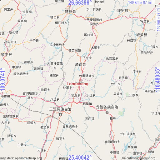
Longcheng GPS coordinates[2]
26° 2' 2.004" North, 109° 46' 37.992" East
| Map corner | latitude | longitude |
|---|---|---|
| Upper-left | 26.66396°, | 109.0741° |
| Center: | 26.03389°, | 109.77722° |
| Lower-right: | 25.40042°, | 110.48035° |
| Map W x H: | 140.5×140.5 km | = 87.3×87.3mi |
| max Lat: | 53.31946° ⇑82.3% North |
| Longcheng: | 26.03389° |
| min Lat: | ⇓17.7% South 18.22056° |
| min Long | Longcheng | max Long |
| 75.07348° | 109.77722° | 134.28917° |
| W 27.6%⇐ | ⇒72.4% E |
Elevation
Elevation of Longcheng is 483 m = 1585 ft, and this is 1.8 m = 6 ft below average elevation for this country.
| Max E: |
5622 m = 18445 ft | 26.6% |
| Avg. | 484.8 m = 1591 ft | |
| Longcheng | 483 m = 1585 ft | |
Min E: |
-3 m = -10 ft | 73.4% |
See also: China elevation on elevation.city.
Geographical zone
Longcheng is located in North temperate zone (between Tropic of Cancer and the Arctic Circle). Distance of this Northern Tropic circle is 288.8 km =179.5 mi to South.| Distance of | km | miles | from Longcheng |
|---|---|---|---|
| North Pole | 7112.4 | 4419.4 | to North |
| Arctic Circle | 4506.5 | 2800.2 | to North |
| Tropic Cancer | 288.8 | 179.5 | to South |
| Equator | 2894.7 | 1798.7 | to South |


Nearby cities:
15 places around Longcheng: (largest is in red/bold)
• Boyang
32.4 km =20.1 mi,  307°
307°
• Chang’anying
40.3 km =25 mi,  50°
50°
• Dazhai
44.8 km =27.8 mi,  123°
123°
• Diyangping
31.7 km =19.7 mi,  326°
326°
• Guyi
33.5 km =20.8 mi,  211°
211°
• Hongzhou
38.2 km =23.7 mi,  285°
285°
• Jiangtousi
40.8 km =25.4 mi,  74°
74°
• Le’anpu Miaozudongzuxiang
52.7 km =32.7 mi,  13°
13°
• Linkou
25.3 km =15.7 mi,  19°
19°
• Longsheng
35.4 km =22 mi,  139°
139°
• Shuangjiang
14.8 km =9.2 mi, 334°
• Xianxi
36 km =22.4 mi,  338°
338°
• Yatunpu
20.2 km =12.6 mi, 311°
• Zhaishi Miaozu Dongzuxiang
58.4 km =36.3 mi,  27°
27°
• Zhongchao
56.8 km =35.3 mi,  281°
281°
Sources, notices
• [Note1] Compared only with cities in China existing in our database
• [Src1] Map data: © OpenStreetMap contributors (CC-BY-SA)
• [Src2] Other city data from geonames.org with taken over terms of usage.
• [Src3] Geographical zone / Annual Mean Temperature by Robert A. Rohde @ Wikipedia
