Leiyang geodata
Leiyang (Hunan) is a seat of a third-order administrative division; located in China in Asia/Shanghai (GMT+8) time zone. With population of 129,116 people, there are 341 cities with bigger population in this country. Compared to other cities in China, 80.8% of cities are located further ↑North; 58.4% of cities are located further →East and 65.8% of cities have higher elevation than Leiyang. Note1


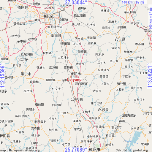
Leiyang GPS coordinates[2]
26° 24' 8.568" North, 112° 51' 32.688" East
| Map corner | latitude | longitude |
|---|---|---|
| Upper-left | 27.03044°, | 112.15596° |
| Center: | 26.40238°, | 112.85908° |
| Lower-right: | 25.77089°, | 113.56221° |
| Map W x H: | 140×140.1 km | = 87×87.1mi |
| max Lat: | 53.31946° ⇑80.8% North |
| Leiyang: | 26.40238° |
| min Lat: | ⇓19.2% South 18.22056° |
| min Long | Leiyang | max Long |
| 75.07348° | 112.85908° | 134.28917° |
| W 41.6%⇐ | ⇒58.4% E |
Elevation
Elevation of Leiyang is 69 m = 226 ft, and this is 415.8 m = 1364 ft below average elevation for this country.
| Max E: |
5622 m = 18445 ft | 65.8% |
| Avg. | 484.8 m = 1591 ft | |
| Leiyang | 69 m = 226 ft | |
Min E: |
-3 m = -10 ft | 34.2% |
See also: Leiyang elevation on elevation.city.
Geographical zone
Leiyang is located in North temperate zone (between Tropic of Cancer and the Arctic Circle). Distance of this Northern Tropic circle is 329.8 km =204.9 mi to South.| Distance of | km | miles | from Leiyang |
|---|---|---|---|
| North Pole | 7071.4 | 4394 | to North |
| Arctic Circle | 4465.5 | 2774.7 | to North |
| Tropic Cancer | 329.8 | 204.9 | to South |
| Equator | 2935.7 | 1824.2 | to South |


Nearby cities:
15 places around Leiyang: (largest is in red/bold)
• Anren Chengguanzhen
53.4 km =33.2 mi,  49°
49°
• Chenzhou
69.2 km =43 mi,  165°
165°
• Guiyang Chengguanzhen
75.2 km =46.7 mi,  188°
188°
• Hengdong Chengguanzhen
76.3 km =47.4 mi,  6°
6°
• Hengyang
59.2 km =36.8 mi,  336°
336°
• Huanxi
76 km =47.2 mi,  76°
76°
• Jieshou
59 km =36.7 mi,  67°
67°
• Lianhua
77.3 km =48 mi,  228°
228°
• Majiang
76 km =47.2 mi,  63°
63°
• Pingshui
72.8 km =45.2 mi, 47°
• Tangdong
59.4 km =36.9 mi,  138°
138°
• Yiyang
47.8 km =29.7 mi,  268°
268°
• Yongxing Chengguanzhen
41 km =25.5 mi, 139°
• Yunji
37.5 km =23.3 mi,  329°
329°
• Zaoshi
65.5 km =40.7 mi, 62°
Sources, notices
• [Note1] Compared only with cities in China existing in our database
• [Src1] Map data: © OpenStreetMap contributors (CC-BY-SA)
• [Src2] Other city data from geonames.org with taken over terms of usage.
• [Src3] Geographical zone / Annual Mean Temperature by Robert A. Rohde @ Wikipedia
