Hengyang geodata
Hengyang (Hunan) is a populated place; located in China in Asia/Shanghai (GMT+8) time zone. With population of 759,602 people, there are 81 cities with bigger population in this country. Compared to other cities in China, 79.1% of cities are located further ↑North; 59.5% of cities are located further →East and 66.6% of cities have higher elevation than Hengyang. Note1


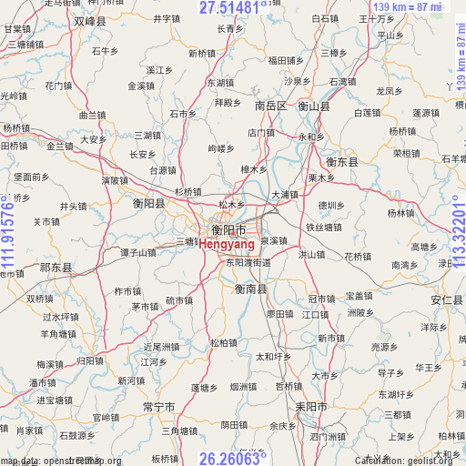
Hengyang GPS coordinates[2]
26° 53' 22.056" North, 112° 37' 7.968" East
| Map corner | latitude | longitude |
|---|---|---|
| Upper-left | 27.51481°, | 111.91576° |
| Center: | 26.88946°, | 112.61888° |
| Lower-right: | 26.26063°, | 113.32201° |
| Map W x H: | 139.5×139.5 km | = 86.7×86.7mi |
| max Lat: | 53.31946° ⇑79.1% North |
| Hengyang: | 26.88946° |
| min Lat: | ⇓20.9% South 18.22056° |
| min Long | Hengyang | max Long |
| 75.07348° | 112.61888° | 134.28917° |
| W 40.5%⇐ | ⇒59.5% E |
Elevation
Elevation of Hengyang is 66 m = 217 ft, and this is 418.8 m = 1374 ft below average elevation for this country.
| Max E: |
5622 m = 18445 ft | 66.6% |
| Avg. | 484.8 m = 1591 ft | |
| Hengyang | 66 m = 217 ft | |
Min E: |
-3 m = -10 ft | 33.4% |
See also: Hengyang elevation on elevation.city.
Geographical zone
Hengyang is located in North temperate zone (between Tropic of Cancer and the Arctic Circle). Distance of this Northern Tropic circle is 383.9 km =238.5 mi to South.| Distance of | km | miles | from Hengyang |
|---|---|---|---|
| North Pole | 7017.2 | 4360.3 | to North |
| Arctic Circle | 4411.3 | 2741.1 | to North |
| Tropic Cancer | 383.9 | 238.5 | to South |
| Equator | 2989.8 | 1857.8 | to South |


Nearby cities:
15 places around Hengyang: (largest is in red/bold)
• Anren Chengguanzhen
67.2 km =41.8 mi,  106°
106°
• Bojia
79.9 km =49.6 mi,  234°
234°
• Hengdong Chengguanzhen
39.3 km =24.4 mi,  56°
56°
• Hongqiao
52.4 km =32.6 mi,  255°
255°
• Huju
76.5 km =47.5 mi,  87°
87°
• Jieshou
84.2 km =52.3 mi, 111°
• Kaiyun
43 km =26.7 mi,  33°
33°
• Leiyang
59.2 km =36.8 mi,  156°
156°
• Pingshui
77.8 km =48.3 mi, 93°
• Wuxi
82.7 km =51.4 mi,  245°
245°
• Xidu
25.9 km =16.1 mi,  286°
286°
• Yiyang
60.5 km =37.6 mi,  203°
203°
• Yongfeng
73.8 km =45.9 mi,  324°
324°
• Youxian Chengguanzhen
74.4 km =46.2 mi,  81°
81°
• Yunji
22.3 km =13.9 mi,  167°
167°
Sources, notices
• [Note1] Compared only with cities in China existing in our database
• [Src1] Map data: © OpenStreetMap contributors (CC-BY-SA)
• [Src2] Other city data from geonames.org with taken over terms of usage.
• [Src3] Geographical zone / Annual Mean Temperature by Robert A. Rohde @ Wikipedia
