Chenzhou geodata
Chenzhou (Hunan) is a seat of a second-order administrative division; located in China in Asia/Shanghai (GMT+8) time zone. With population of 179,038 people, there are 252 cities with bigger population in this country. Compared to other cities in China, 83.2% of cities are located further ↑North; 57.4% of cities are located further →East and 51.9% of cities have lower elevation than Chenzhou. Note1


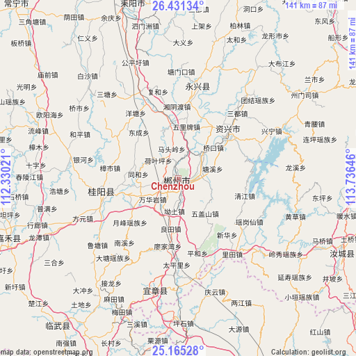
Chenzhou GPS coordinates[2]
25° 48' 0" North, 113° 1' 59.988" East
| Map corner | latitude | longitude |
|---|---|---|
| Upper-left | 26.43134°, | 112.33021° |
| Center: | 25.8°, | 113.03333° |
| Lower-right: | 25.16528°, | 113.73646° |
| Map W x H: | 140.8×140.8 km | = 87.5×87.5mi |
| max Lat: | 53.31946° ⇑83.2% North |
| Chenzhou: | 25.8° |
| min Lat: | ⇓16.8% South 18.22056° |
| min Long | Chenzhou | max Long |
| 75.07348° | 113.03333° | 134.28917° |
| W 42.6%⇐ | ⇒57.4% E |
Elevation
Elevation of Chenzhou is 180 m = 591 ft, and this is 304.8 m = 1000 ft below average elevation for this country.
| Max E: |
5622 m = 18445 ft | 48.1% |
| Avg. | 484.8 m = 1591 ft | |
| Chenzhou | 180 m = 591 ft | |
Min E: |
-3 m = -10 ft | 51.9% |
See also: Chenzhou elevation on elevation.city.
Geographical zone
Chenzhou is located in North temperate zone (between Tropic of Cancer and the Arctic Circle). Distance of this Northern Tropic circle is 262.8 km =163.3 mi to South.| Distance of | km | miles | from Chenzhou |
|---|---|---|---|
| North Pole | 7138.4 | 4435.6 | to North |
| Arctic Circle | 4532.5 | 2816.4 | to North |
| Tropic Cancer | 262.8 | 163.3 | to South |
| Equator | 2868.7 | 1782.5 | to South |


Nearby cities:
15 places around Chenzhou: (largest is in red/bold)
• Baishi
44.6 km =27.7 mi,  150°
150°
• Dayuan
63.7 km =39.6 mi,  156°
156°
• Guiyang Chengguanzhen
29.7 km =18.5 mi,  255°
255°
• Huangpu
43.3 km =26.9 mi, 161°
• Jiufeng
60.2 km =37.4 mi, 146°
• Leiyang
69.2 km =43 mi,  345°
345°
• Liangjiang
54.6 km =33.9 mi, 150°
• Meihua
69.4 km =43.1 mi,  176°
176°
• Pingshi
57.3 km =35.6 mi, 177°
• Qingyun
47.8 km =29.7 mi, 162°
• Sanxi
59.9 km =37.2 mi,  192°
192°
• Tangdong
31.5 km =19.6 mi,  44°
44°
• Xinlong
68.3 km =42.4 mi,  268°
268°
• Yizhang Chengguanzhen
46.7 km =29 mi, 186°
• Yongxing Chengguanzhen
37.3 km =23.2 mi,  14°
14°
Sources, notices
• [Note1] Compared only with cities in China existing in our database
• [Src1] Map data: © OpenStreetMap contributors (CC-BY-SA)
• [Src2] Other city data from geonames.org with taken over terms of usage.
• [Src3] Geographical zone / Annual Mean Temperature by Robert A. Rohde @ Wikipedia
