Tangdong geodata
Tangdong (Hunan) is a seat of a third-order administrative division; located in China in Asia/Shanghai (GMT+8) time zone. In our database, there are 1268 cities with bigger population. Compared to other cities in China, 82.3% of cities are located further ↑North; 55.9% of cities are located further →East and 55.1% of cities have higher elevation than Tangdong. Note1


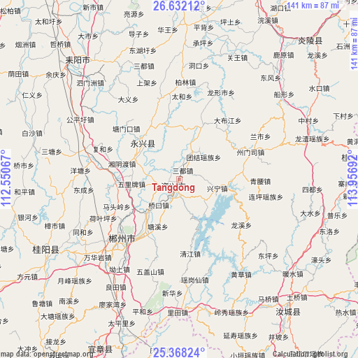
Tangdong GPS coordinates[2]
26° 0' 6.768" North, 113° 15' 13.644" East
| Map corner | latitude | longitude |
|---|---|---|
| Upper-left | 26.63212°, | 112.55067° |
| Center: | 26.00188°, | 113.25379° |
| Lower-right: | 25.36824°, | 113.95692° |
| Map W x H: | 140.5×140.5 km | = 87.3×87.3mi |
| max Lat: | 53.31946° ⇑82.3% North |
| Tangdong: | 26.00188° |
| min Lat: | ⇓17.7% South 18.22056° |
| min Long | Tangdong | max Long |
| 75.07348° | 113.25379° | 134.28917° |
| W 44.1%⇐ | ⇒55.9% E |
Elevation
Elevation of Tangdong is 131 m = 430 ft, and this is 353.8 m = 1161 ft below average elevation for this country.
| Max E: |
5622 m = 18445 ft | 55.1% |
| Avg. | 484.8 m = 1591 ft | |
| Tangdong | 131 m = 430 ft | |
Min E: |
-3 m = -10 ft | 44.9% |
See also: China elevation on elevation.city.
Geographical zone
Tangdong is located in North temperate zone (between Tropic of Cancer and the Arctic Circle). Distance of this Northern Tropic circle is 285.2 km =177.2 mi to South.| Distance of | km | miles | from Tangdong |
|---|---|---|---|
| North Pole | 7115.9 | 4421.6 | to North |
| Arctic Circle | 4510 | 2802.4 | to North |
| Tropic Cancer | 285.2 | 177.2 | to South |
| Equator | 2891.1 | 1796.4 | to South |


Nearby cities:
15 places around Tangdong: (largest is in red/bold)
• Baishi
61.2 km =38 mi,  180°
180°
• Chenzhou
31.5 km =19.6 mi,  224°
224°
• Guidong Chengguanzhen
69.1 km =42.9 mi,  82°
82°
• Guiyang Chengguanzhen
58.9 km =36.6 mi,  239°
239°
• Huangpu
63.9 km =39.7 mi,  187°
187°
• Huanxi
71.4 km =44.4 mi,  28°
28°
• Jieshou
68.9 km =42.8 mi,  12°
12°
• Jiufeng
73.4 km =45.6 mi,  171°
171°
• Leiyang
59.4 km =36.9 mi,  318°
318°
• Liangjiang
70.2 km =43.6 mi, 176°
• Qingyun
68.5 km =42.6 mi, 186°
• Rucheng Chengguanzhen
69.4 km =43.1 mi,  138°
138°
• Xiayang
74.6 km =46.4 mi,  43°
43°
• Yizhang Chengguanzhen
74.1 km =46 mi,  201°
201°
• Yongxing Chengguanzhen
18.5 km =11.5 mi, 317°
Sources, notices
• [Note1] Compared only with cities in China existing in our database
• [Src1] Map data: © OpenStreetMap contributors (CC-BY-SA)
• [Src2] Other city data from geonames.org with taken over terms of usage.
• [Src3] Geographical zone / Annual Mean Temperature by Robert A. Rohde @ Wikipedia
