Langxi geodata
Langxi (Guizhou) is a seat of a fourth-order administrative division; located in China in Asia/Shanghai (GMT+8) time zone. In our database, there are 1268 cities with bigger population. Compared to other cities in China, 74% of cities are located further ↑North; 78.6% of cities are located further →East and 74.5% of cities have lower elevation than Langxi. Note1


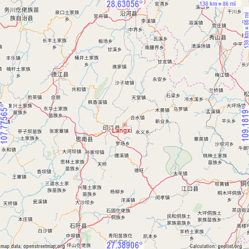
Langxi GPS coordinates[2]
28° 0' 41.76" North, 108° 28' 43.572" East
| Map corner | latitude | longitude |
|---|---|---|
| Upper-left | 28.63056°, | 107.77565° |
| Center: | 28.0116°, | 108.47877° |
| Lower-right: | 27.38906°, | 109.1819° |
| Map W x H: | 138×138 km | = 85.7×85.7mi |
| max Lat: | 53.31946° ⇑74% North |
| Langxi: | 28.0116° |
| min Lat: | ⇓26% South 18.22056° |
| min Long | Langxi | max Long |
| 75.07348° | 108.47877° | 134.28917° |
| W 21.4%⇐ | ⇒78.6% E |
Elevation
Elevation of Langxi is 510 m = 1673 ft, and this is 25.2 m = 83 ft above average elevation for this country.
| Max E: |
5622 m = 18445 ft | 25.5% |
| Langxi | 510 m 1673 ft | |
| Avg. | 484.8 m = 1591 ft | |
Min E: |
-3 m = -10 ft | 74.5% |
See also: China elevation on elevation.city.
Geographical zone
Langxi is located in North temperate zone (between Tropic of Cancer and the Arctic Circle). Distance of this Northern Tropic circle is 508.7 km =316.1 mi to South.| Distance of | km | miles | from Langxi |
|---|---|---|---|
| North Pole | 6892.5 | 4282.8 | to North |
| Arctic Circle | 4286.6 | 2663.6 | to North |
| Tropic Cancer | 508.7 | 316.1 | to South |
| Equator | 3114.6 | 1935.3 | to South |


Nearby cities:
15 places around Langxi: (largest is in red/bold)
• Banxi
6.9 km =4.3 mi,  351°
351°
• Changbao
27.9 km =17.3 mi,  315°
315°
• Chaodi
26.2 km =16.3 mi,  292°
292°
• Daoba
27.5 km =17.1 mi,  22°
22°
• Eling
7.7 km =4.8 mi,  260°
260°
• Fengxiangxi
19.9 km =12.4 mi,  310°
310°
• Heshui
8.2 km =5.1 mi,  57°
57°
• Muhuang
22.4 km =13.9 mi,  67°
67°
• Shanshu
12.9 km =8 mi,  329°
329°
• Shazipo
23.6 km =14.7 mi,  359°
359°
• Tiantang
17.6 km =10.9 mi,  26°
26°
• Wuluo
32.1 km =19.9 mi, 73°
• Xinye
21.3 km =13.2 mi,  81°
81°
• Yong’an
32 km =19.9 mi,  36°
36°
• Zhongba
14.2 km =8.8 mi,  276°
276°
Sources, notices
• [Note1] Compared only with cities in China existing in our database
• [Src1] Map data: © OpenStreetMap contributors (CC-BY-SA)
• [Src2] Other city data from geonames.org with taken over terms of usage.
• [Src3] Geographical zone / Annual Mean Temperature by Robert A. Rohde @ Wikipedia
