Eling geodata
Eling (Guizhou) is a seat of a third-order administrative division; located in China in Asia/Shanghai (GMT+8) time zone. In our database, there are 1268 cities with bigger population. Compared to other cities in China, 74.1% of cities are located further ↑North; 79% of cities are located further →East and 72.3% of cities have lower elevation than Eling. Note1


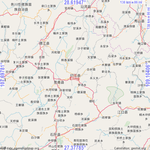
Eling GPS coordinates[2]
28° 0' 1.62" North, 108° 24' 3.348" East
| Map corner | latitude | longitude |
|---|---|---|
| Upper-left | 28.61947°, | 107.69781° |
| Center: | 28.00045°, | 108.40093° |
| Lower-right: | 27.37785°, | 109.10406° |
| Map W x H: | 138.1×138.1 km | = 85.8×85.8mi |
| max Lat: | 53.31946° ⇑74.1% North |
| Eling: | 28.00045° |
| min Lat: | ⇓25.9% South 18.22056° |
| min Long | Eling | max Long |
| 75.07348° | 108.40093° | 134.28917° |
| W 21%⇐ | ⇒79% E |
Elevation
Elevation of Eling is 460 m = 1509 ft, and this is 24.8 m = 81 ft below average elevation for this country.
| Max E: |
5622 m = 18445 ft | 27.7% |
| Avg. | 484.8 m = 1591 ft | |
| Eling | 460 m = 1509 ft | |
Min E: |
-3 m = -10 ft | 72.3% |
See also: China elevation on elevation.city.
Geographical zone
Eling is located in North temperate zone (between Tropic of Cancer and the Arctic Circle). Distance of this Northern Tropic circle is 507.4 km =315.3 mi to South.| Distance of | km | miles | from Eling |
|---|---|---|---|
| North Pole | 6893.7 | 4283.5 | to North |
| Arctic Circle | 4287.8 | 2664.3 | to North |
| Tropic Cancer | 507.4 | 315.3 | to South |
| Equator | 3113.4 | 1934.6 | to South |


Nearby cities:
15 places around Eling: (largest is in red/bold)
• Banxi
10.4 km =6.5 mi,  39°
39°
• Changbao
24.3 km =15.1 mi,  330°
330°
• Chaodi
20 km =12.4 mi,  304°
304°
• Dabachang
29.2 km =18.1 mi,  191°
191°
• Fengxiangxi
16 km =9.9 mi, 331°
• Gonghe
28.7 km =17.8 mi,  320°
320°
• Heshui
15.7 km =9.8 mi,  69°
69°
• Langxi
7.7 km =4.8 mi,  80°
80°
• Muhuang
29.9 km =18.6 mi, 71°
• Shanshu
12.4 km =7.7 mi,  4°
4°
• Shazipo
25.9 km =16.1 mi,  16°
16°
• Tiantang
23 km =14.3 mi, 42°
• Xinye
29.1 km =18.1 mi, 81°
• Xujiaba
31 km =19.3 mi,  245°
245°
• Zhongba
7.1 km =4.4 mi,  293°
293°
Sources, notices
• [Note1] Compared only with cities in China existing in our database
• [Src1] Map data: © OpenStreetMap contributors (CC-BY-SA)
• [Src2] Other city data from geonames.org with taken over terms of usage.
• [Src3] Geographical zone / Annual Mean Temperature by Robert A. Rohde @ Wikipedia
