Cannei geodata
Cannei (Fujian) is a seat of a fourth-order administrative division; located in China in Asia/Shanghai (GMT+8) time zone. In our database, there are 1268 cities with bigger population. Compared to other cities in China, 86% of cities are located further ↑North; 71.6% of cities are located further ←West and 76.7% of cities have higher elevation than Cannei. Note1


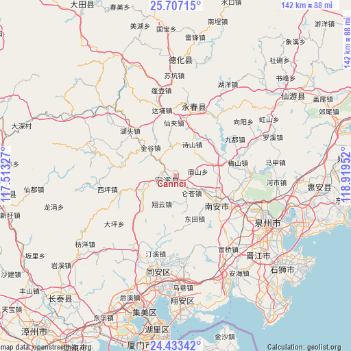
Cannei GPS coordinates[2]
25° 4' 18.984" North, 118° 12' 59.004" East
| Map corner | latitude | longitude |
|---|---|---|
| Upper-left | 25.70715°, | 117.51327° |
| Center: | 25.07194°, | 118.21639° |
| Lower-right: | 24.43342°, | 118.91952° |
| Map W x H: | 141.6×141.6 km | = 88×88mi |
| max Lat: | 53.31946° ⇑86% North |
| Cannei: | 25.07194° |
| min Lat: | ⇓14% South 18.22056° |
| min Long | Cannei | max Long |
| 75.07348° | 118.21639° | 134.28917° |
| W 71.6%⇐ | ⇒28.4% E |
Elevation
Elevation of Cannei is 33 m = 108 ft, and this is 451.8 m = 1482 ft below average elevation for this country.
| Max E: |
5622 m = 18445 ft | 76.7% |
| Avg. | 484.8 m = 1591 ft | |
| Cannei | 33 m = 108 ft | |
Min E: |
-3 m = -10 ft | 23.3% |
See also: China elevation on elevation.city.
Geographical zone
Cannei is located in North temperate zone (between Tropic of Cancer and the Arctic Circle). Distance of this Northern Tropic circle is 181.8 km =113 mi to South.| Distance of | km | miles | from Cannei |
|---|---|---|---|
| North Pole | 7219.3 | 4485.9 | to North |
| Arctic Circle | 4613.4 | 2866.6 | to North |
| Tropic Cancer | 181.8 | 113 | to South |
| Equator | 2787.7 | 1732.2 | to South |


Nearby cities:
15 places around Cannei: (largest is in red/bold)
• Chengxiang
4 km =2.5 mi,  221°
221°
• Fengcheng
3.8 km =2.4 mi,  243°
243°
• Guanqiao
14.1 km =8.8 mi,  247°
247°
• Jingu
15.1 km =9.4 mi,  317°
317°
• Jintao
14.7 km =9.1 mi,  68°
68°
• Kuidou
9.2 km =5.7 mi, 317°
• Longmen
17.9 km =11.1 mi,  225°
225°
• Luncang
9.5 km =5.9 mi,  136°
136°
• Meishan
8.8 km =5.5 mi,  81°
81°
• Penghua
13.9 km =8.6 mi,  350°
350°
• Penglai
14.3 km =8.9 mi,  298°
298°
• Shengxin
17.2 km =10.7 mi,  103°
103°
• Xiangyun
12.6 km =7.8 mi,  206°
206°
• Ximei
19.5 km =12.1 mi,  118°
118°
• Yingdu
11.5 km =7.1 mi,  165°
165°
Sources, notices
• [Note1] Compared only with cities in China existing in our database
• [Src1] Map data: © OpenStreetMap contributors (CC-BY-SA)
• [Src2] Other city data from geonames.org with taken over terms of usage.
• [Src3] Geographical zone / Annual Mean Temperature by Robert A. Rohde @ Wikipedia
