Xiangyun geodata
Xiangyun (Fujian) is a populated place; located in China in Asia/Shanghai (GMT+8) time zone. With population of 1,800 people, there are 1053 cities with bigger population in this country. Compared to other cities in China, 86.5% of cities are located further ↑North; 71.3% of cities are located further ←West and 73.9% of cities have lower elevation than Xiangyun. Note1


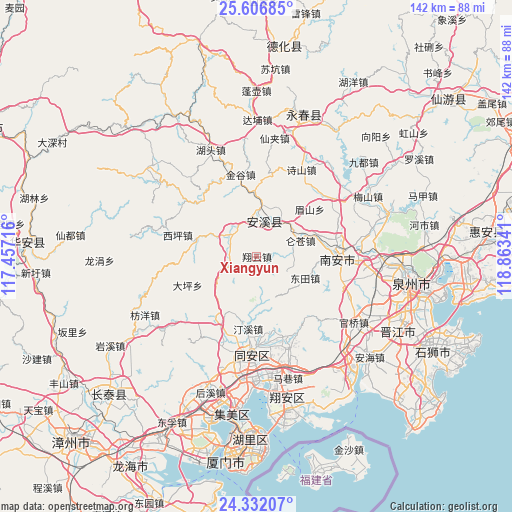
Xiangyun GPS coordinates[2]
24° 58' 15.996" North, 118° 9' 37.008" East
| Map corner | latitude | longitude |
|---|---|---|
| Upper-left | 25.60685°, | 117.45716° |
| Center: | 24.97111°, | 118.16028° |
| Lower-right: | 24.33207°, | 118.86341° |
| Map W x H: | 141.7×141.7 km | = 88×88mi |
| max Lat: | 53.31946° ⇑86.5% North |
| Xiangyun: | 24.97111° |
| min Lat: | ⇓13.5% South 18.22056° |
| min Long | Xiangyun | max Long |
| 75.07348° | 118.16028° | 134.28917° |
| W 71.3%⇐ | ⇒28.7% E |
Elevation
Elevation of Xiangyun is 497 m = 1631 ft, and this is 12.2 m = 40 ft above average elevation for this country.
| Max E: |
5622 m = 18445 ft | 26.1% |
| Xiangyun | 497 m 1631 ft | |
| Avg. | 484.8 m = 1591 ft | |
Min E: |
-3 m = -10 ft | 73.9% |
See also: China elevation on elevation.city.
Geographical zone
Xiangyun is located in North temperate zone (between Tropic of Cancer and the Arctic Circle). Distance of this Northern Tropic circle is 170.6 km =106 mi to South.| Distance of | km | miles | from Xiangyun |
|---|---|---|---|
| North Pole | 7230.5 | 4492.8 | to North |
| Arctic Circle | 4624.6 | 2873.6 | to North |
| Tropic Cancer | 170.6 | 106 | to South |
| Equator | 2776.5 | 1725.2 | to South |


Nearby cities:
15 places around Xiangyun: (largest is in red/bold)
• Cannei
12.6 km =7.8 mi,  26°
26°
• Chengxiang
8.7 km =5.4 mi,  19°
19°
• Fengcheng
9.8 km =6.1 mi,  13°
13°
• Guanqiao
9.3 km =5.8 mi,  307°
307°
• Huqiu
17.6 km =10.9 mi,  281°
281°
• Jingu
22.8 km =14.2 mi,  348°
348°
• Kuidou
18.1 km =11.2 mi,  358°
358°
• Longmen
7.3 km =4.5 mi,  260°
260°
• Luncang
12.9 km =8 mi,  70°
70°
• Meishan
19.1 km =11.9 mi,  48°
48°
• Penglai
19.2 km =11.9 mi,  338°
338°
• Shengxin
23.6 km =14.7 mi, 71°
• Ximei
22.8 km =14.2 mi,  85°
85°
• Xiping
23 km =14.3 mi,  285°
285°
• Yingdu
8.5 km =5.3 mi, 89°
Sources, notices
• [Note1] Compared only with cities in China existing in our database
• [Src1] Map data: © OpenStreetMap contributors (CC-BY-SA)
• [Src2] Other city data from geonames.org with taken over terms of usage.
• [Src3] Geographical zone / Annual Mean Temperature by Robert A. Rohde @ Wikipedia
