Luncang geodata
Luncang (Fujian) is a seat of a fourth-order administrative division; located in China in Asia/Shanghai (GMT+8) time zone. In our database, there are 1268 cities with bigger population. Compared to other cities in China, 86.3% of cities are located further ↑North; 71.8% of cities are located further ←West and 74.4% of cities have higher elevation than Luncang. Note1


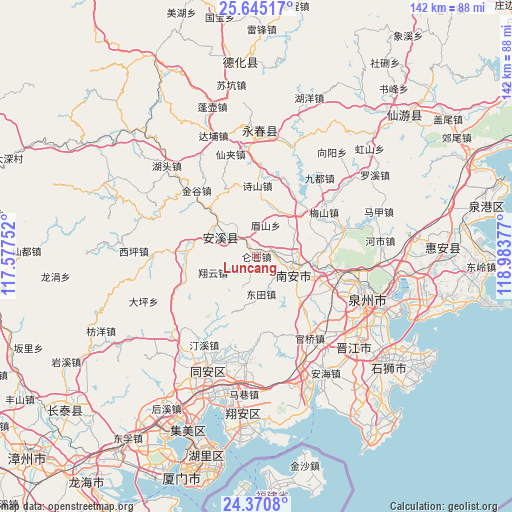
Luncang GPS coordinates[2]
25° 0' 34.704" North, 118° 16' 50.304" East
| Map corner | latitude | longitude |
|---|---|---|
| Upper-left | 25.64517°, | 117.57752° |
| Center: | 25.00964°, | 118.28064° |
| Lower-right: | 24.3708°, | 118.98377° |
| Map W x H: | 141.7×141.7 km | = 88×88mi |
| max Lat: | 53.31946° ⇑86.3% North |
| Luncang: | 25.00964° |
| min Lat: | ⇓13.7% South 18.22056° |
| min Long | Luncang | max Long |
| 75.07348° | 118.28064° | 134.28917° |
| W 71.8%⇐ | ⇒28.2% E |
Elevation
Elevation of Luncang is 38 m = 125 ft, and this is 446.8 m = 1466 ft below average elevation for this country.
| Max E: |
5622 m = 18445 ft | 74.4% |
| Avg. | 484.8 m = 1591 ft | |
| Luncang | 38 m = 125 ft | |
Min E: |
-3 m = -10 ft | 25.6% |
See also: China elevation on elevation.city.
Geographical zone
Luncang is located in North temperate zone (between Tropic of Cancer and the Arctic Circle). Distance of this Northern Tropic circle is 174.9 km =108.7 mi to South.| Distance of | km | miles | from Luncang |
|---|---|---|---|
| North Pole | 7226.3 | 4490.2 | to North |
| Arctic Circle | 4620.4 | 2871 | to North |
| Tropic Cancer | 174.9 | 108.7 | to South |
| Equator | 2780.8 | 1727.9 | to South |


Nearby cities:
15 places around Luncang: (largest is in red/bold)
• Cannei
9.5 km =5.9 mi,  316°
316°
• Chengxiang
10 km =6.2 mi,  293°
293°
• Fengcheng
11.2 km =7 mi,  298°
298°
• Guanqiao
19.5 km =12.1 mi,  274°
274°
• Jintao
14.3 km =8.9 mi,  30°
30°
• Kangmei
19.4 km =12.1 mi,  80°
80°
• Kuidou
18.7 km =11.6 mi, 317°
• Longmen
20.1 km =12.5 mi,  253°
253°
• Matou
22 km =13.7 mi,  22°
22°
• Meishan
8.6 km =5.3 mi, 15°
• Shengxin
10.7 km =6.6 mi,  73°
73°
• Xiamei
21.4 km =13.3 mi,  111°
111°
• Xiangyun
12.9 km =8 mi, 250°
• Ximei
10.9 km =6.8 mi,  102°
102°
• Yingdu
5.6 km =3.5 mi,  221°
221°
Sources, notices
• [Note1] Compared only with cities in China existing in our database
• [Src1] Map data: © OpenStreetMap contributors (CC-BY-SA)
• [Src2] Other city data from geonames.org with taken over terms of usage.
• [Src3] Geographical zone / Annual Mean Temperature by Robert A. Rohde @ Wikipedia
