Juancheng geodata
Juancheng (Shandong) is a seat of a third-order administrative division; located in China in Asia/Shanghai (GMT+8) time zone. In our database, there are 1268 cities with bigger population. Compared to other cities in China, 76.1% of cities are located further ↓South; 57% of cities are located further ←West and 70% of cities have higher elevation than Juancheng. Note1


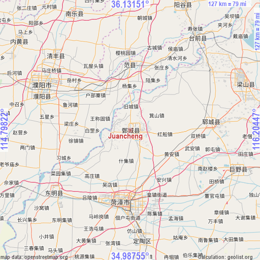
Juancheng GPS coordinates[2]
35° 33' 41.652" North, 115° 30' 4.824" East
| Map corner | latitude | longitude |
|---|---|---|
| Upper-left | 36.13151°, | 114.79822° |
| Center: | 35.56157°, | 115.50134° |
| Lower-right: | 34.98755°, | 116.20447° |
| Map W x H: | 127.2×127.2 km | = 79×79mi |
| max Lat: | 53.31946° ⇑23.9% North |
| Juancheng: | 35.56157° |
| min Lat: | ⇓76.1% South 18.22056° |
| min Long | Juancheng | max Long |
| 75.07348° | 115.50134° | 134.28917° |
| W 57%⇐ | ⇒43% E |
Elevation
Elevation of Juancheng is 52 m = 171 ft, and this is 432.8 m = 1420 ft below average elevation for this country.
| Max E: |
5622 m = 18445 ft | 70% |
| Avg. | 484.8 m = 1591 ft | |
| Juancheng | 52 m = 171 ft | |
Min E: |
-3 m = -10 ft | 30% |
See also: China elevation on elevation.city.
Geographical zone
Juancheng is located in North temperate zone (between Tropic of Cancer and the Arctic Circle). Distance of this Northern Tropic circle is 1348.2 km =837.7 mi to South.| Distance of | km | miles | from Juancheng |
|---|---|---|---|
| North Pole | 6053 | 3761.2 | to North |
| Arctic Circle | 3447.1 | 2141.9 | to North |
| Tropic Cancer | 1348.2 | 837.7 | to South |
| Equator | 3954.1 | 2457 | to South |


Nearby cities:
15 places around Juancheng: (largest is in red/bold)
• Chengguan
44.6 km =27.7 mi,  231°
231°
• Dingtao
54.5 km =33.9 mi,  173°
173°
• Dongming Chengguanzhen
47.9 km =29.8 mi, 231°
• Fan Xian Chengguanzhen
33 km =20.5 mi,  359°
359°
• Heze
35.9 km =22.3 mi,  184°
184°
• Juye
56.3 km =35 mi,  109°
109°
• Nanle Chengguanzhen
63.4 km =39.4 mi,  334°
334°
• Puyang
49.1 km =30.5 mi,  297°
297°
• Puyang Chengguanzhen
46.8 km =29.1 mi,  289°
289°
• Qingfeng Chengguanzhen
52.2 km =32.4 mi,  316°
316°
• Xicheng
35.6 km =22.1 mi,  189°
189°
• Yanggu
65.8 km =40.9 mi,  22°
22°
• Yangying
49.4 km =30.7 mi,  54°
54°
• Yuncheng
39.4 km =24.5 mi,  84°
84°
• Zhongyuanlu
45.9 km =28.5 mi, 300°
Sources, notices
• [Note1] Compared only with cities in China existing in our database
• [Src1] Map data: © OpenStreetMap contributors (CC-BY-SA)
• [Src2] Other city data from geonames.org with taken over terms of usage.
• [Src3] Geographical zone / Annual Mean Temperature by Robert A. Rohde @ Wikipedia
