Heze geodata
Heze (Shandong) is a seat of a second-order administrative division; located in China in Asia/Shanghai (GMT+8) time zone. With population of 254,602 people, there are 197 cities with bigger population in this country. Compared to other cities in China, 75.5% of cities are located further ↓South; 56.8% of cities are located further ←West and 69.7% of cities have higher elevation than Heze. Note1


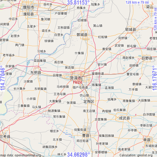
Heze GPS coordinates[2]
35° 14' 21.444" North, 115° 28' 24.888" East
| Map corner | latitude | longitude |
|---|---|---|
| Upper-left | 35.81153°, | 114.77046° |
| Center: | 35.23929°, | 115.47358° |
| Lower-right: | 34.66298°, | 116.17671° |
| Map W x H: | 127.7×127.7 km | = 79.3×79.3mi |
| max Lat: | 53.31946° ⇑24.5% North |
| Heze: | 35.23929° |
| min Lat: | ⇓75.5% South 18.22056° |
| min Long | Heze | max Long |
| 75.07348° | 115.47358° | 134.28917° |
| W 56.8%⇐ | ⇒43.2% E |
Elevation
Elevation of Heze is 53 m = 174 ft, and this is 431.8 m = 1417 ft below average elevation for this country.
| Max E: |
5622 m = 18445 ft | 69.7% |
| Avg. | 484.8 m = 1591 ft | |
| Heze | 53 m = 174 ft | |
Min E: |
-3 m = -10 ft | 30.3% |
See also: Heze elevation on elevation.city.
Geographical zone
Heze is located in North temperate zone (between Tropic of Cancer and the Arctic Circle). Distance of this Northern Tropic circle is 1312.3 km =815.4 mi to South.| Distance of | km | miles | from Heze |
|---|---|---|---|
| North Pole | 6088.8 | 3783.4 | to North |
| Arctic Circle | 3482.9 | 2164.2 | to North |
| Tropic Cancer | 1312.3 | 815.4 | to South |
| Equator | 3918.2 | 2434.7 | to South |


Nearby cities:
15 places around Heze: (largest is in red/bold)
• Changyuan County
67.2 km =41.8 mi,  267°
267°
• Chengguan
33.1 km =20.6 mi,  283°
283°
• Chengwu
49 km =30.4 mi,  130°
130°
• Dingtao
20.2 km =12.6 mi,  155°
155°
• Dongming Chengguanzhen
35.3 km =21.9 mi, 279°
• Fan Xian Chengguanzhen
68.9 km =42.8 mi,  2°
2°
• Juancheng
35.9 km =22.3 mi, 4°
• Juye
58.4 km =36.3 mi,  72°
72°
• Minquan Chengguanzhen
71.1 km =44.2 mi,  205°
205°
• Puxi
71.8 km =44.6 mi, 266°
• Puyang
71.4 km =44.4 mi,  324°
324°
• Puyang Chengguanzhen
66.4 km =41.3 mi, 321°
• Xicheng
3.7 km =2.3 mi, 281°
• Yuncheng
57.8 km =35.9 mi,  46°
46°
• Zhongyuanlu
69.7 km =43.3 mi,  327°
327°
Sources, notices
• [Note1] Compared only with cities in China existing in our database
• [Src1] Map data: © OpenStreetMap contributors (CC-BY-SA)
• [Src2] Other city data from geonames.org with taken over terms of usage.
• [Src3] Geographical zone / Annual Mean Temperature by Robert A. Rohde @ Wikipedia
