Xicheng geodata
Xicheng (Shandong) is a seat of a third-order administrative division; located in China in Asia/Shanghai (GMT+8) time zone. In our database, there are 1268 cities with bigger population. Compared to other cities in China, 75.6% of cities are located further ↓South; 56.6% of cities are located further ←West and 69.2% of cities have higher elevation than Xicheng. Note1


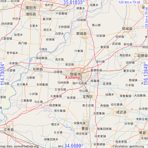
Xicheng GPS coordinates[2]
35° 14' 46.176" North, 115° 26' 0.096" East
| Map corner | latitude | longitude |
|---|---|---|
| Upper-left | 35.81835°, | 114.73024° |
| Center: | 35.24616°, | 115.43336° |
| Lower-right: | 34.6699°, | 116.13649° |
| Map W x H: | 127.7×127.7 km | = 79.3×79.3mi |
| max Lat: | 53.31946° ⇑24.4% North |
| Xicheng: | 35.24616° |
| min Lat: | ⇓75.6% South 18.22056° |
| min Long | Xicheng | max Long |
| 75.07348° | 115.43336° | 134.28917° |
| W 56.6%⇐ | ⇒43.4% E |
Elevation
Elevation of Xicheng is 55 m = 180 ft, and this is 429.8 m = 1410 ft below average elevation for this country.
| Max E: |
5622 m = 18445 ft | 69.2% |
| Avg. | 484.8 m = 1591 ft | |
| Xicheng | 55 m = 180 ft | |
Min E: |
-3 m = -10 ft | 30.8% |
See also: China elevation on elevation.city.
Geographical zone
Xicheng is located in North temperate zone (between Tropic of Cancer and the Arctic Circle). Distance of this Northern Tropic circle is 1313.1 km =815.9 mi to South.| Distance of | km | miles | from Xicheng |
|---|---|---|---|
| North Pole | 6088.1 | 3783 | to North |
| Arctic Circle | 3482.2 | 2163.7 | to North |
| Tropic Cancer | 1313.1 | 815.9 | to South |
| Equator | 3919 | 2435.2 | to South |


Nearby cities:
15 places around Xicheng: (largest is in red/bold)
• Changyuan County
63.5 km =39.5 mi,  266°
266°
• Chengguan
29.4 km =18.3 mi,  283°
283°
• Chengwu
52.3 km =32.5 mi,  128°
128°
• Dingtao
22.6 km =14 mi,  147°
147°
• Dongming Chengguanzhen
31.6 km =19.6 mi, 279°
• Fan Xian Chengguanzhen
68.3 km =42.4 mi,  5°
5°
• Heze
3.7 km =2.3 mi,  101°
101°
• Juancheng
35.6 km =22.1 mi, 9°
• Juye
61.7 km =38.3 mi,  74°
74°
• Minquan Chengguanzhen
70.2 km =43.6 mi,  202°
202°
• Puxi
68.2 km =42.4 mi, 265°
• Puyang
68.7 km =42.7 mi,  326°
326°
• Puyang Chengguanzhen
63.6 km =39.5 mi,  323°
323°
• Yuncheng
60 km =37.3 mi,  49°
49°
• Zhongyuanlu
67.1 km =41.7 mi, 329°
Sources, notices
• [Note1] Compared only with cities in China existing in our database
• [Src1] Map data: © OpenStreetMap contributors (CC-BY-SA)
• [Src2] Other city data from geonames.org with taken over terms of usage.
• [Src3] Geographical zone / Annual Mean Temperature by Robert A. Rohde @ Wikipedia
