Dingtao geodata
Dingtao (Shandong) is a seat of a third-order administrative division; located in China in Asia/Shanghai (GMT+8) time zone. With population of 58,206 people, there are 757 cities with bigger population in this country. Compared to other cities in China, 75.2% of cities are located further ↓South; 57.4% of cities are located further ←West and 69.7% of cities have higher elevation than Dingtao. Note1


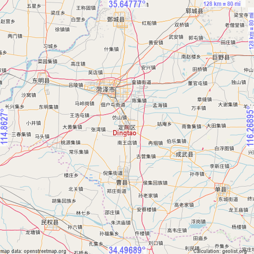
Dingtao GPS coordinates[2]
35° 4' 27.696" North, 115° 33' 56.952" East
| Map corner | latitude | longitude |
|---|---|---|
| Upper-left | 35.64777°, | 114.8627° |
| Center: | 35.07436°, | 115.56582° |
| Lower-right: | 34.49689°, | 116.26895° |
| Map W x H: | 128×128 km | = 79.5×79.5mi |
| max Lat: | 53.31946° ⇑24.8% North |
| Dingtao: | 35.07436° |
| min Lat: | ⇓75.2% South 18.22056° |
| min Long | Dingtao | max Long |
| 75.07348° | 115.56582° | 134.28917° |
| W 57.4%⇐ | ⇒42.6% E |
Elevation
Elevation of Dingtao is 53 m = 174 ft, and this is 431.8 m = 1417 ft below average elevation for this country.
| Max E: |
5622 m = 18445 ft | 69.7% |
| Avg. | 484.8 m = 1591 ft | |
| Dingtao | 53 m = 174 ft | |
Min E: |
-3 m = -10 ft | 30.3% |
See also: Dingtao elevation on elevation.city.
Geographical zone
Dingtao is located in North temperate zone (between Tropic of Cancer and the Arctic Circle). Distance of this Northern Tropic circle is 1294 km =804.1 mi to South.| Distance of | km | miles | from Dingtao |
|---|---|---|---|
| North Pole | 6107.2 | 3794.8 | to North |
| Arctic Circle | 3501.3 | 2175.6 | to North |
| Tropic Cancer | 1294 | 804.1 | to South |
| Equator | 3899.9 | 2423.3 | to South |


Nearby cities:
15 places around Dingtao: (largest is in red/bold)
• Changyuan County
77.1 km =47.9 mi,  281°
281°
• Chengguan
48.3 km =30 mi,  302°
302°
• Chengwu
31.9 km =19.8 mi,  114°
114°
• Dongming Chengguanzhen
49.5 km =30.8 mi, 299°
• Heze
20.2 km =12.6 mi,  335°
335°
• Jiaxiang
79.5 km =49.4 mi,  63°
63°
• Juancheng
54.5 km =33.9 mi,  353°
353°
• Juye
59.3 km =36.8 mi,  53°
53°
• Lankao Chengguanzhen
74.2 km =46.1 mi,  248°
248°
• Minquan Chengguanzhen
60.3 km =37.5 mi,  220°
220°
• Ningling Chengguanzhen
73.1 km =45.4 mi,  198°
198°
• Shancheng
56.3 km =35 mi,  123°
123°
• Shangqiu
69.8 km =43.4 mi,  173°
173°
• Xicheng
22.6 km =14 mi,  327°
327°
• Yuncheng
67.2 km =41.8 mi,  29°
29°
Sources, notices
• [Note1] Compared only with cities in China existing in our database
• [Src1] Map data: © OpenStreetMap contributors (CC-BY-SA)
• [Src2] Other city data from geonames.org with taken over terms of usage.
• [Src3] Geographical zone / Annual Mean Temperature by Robert A. Rohde @ Wikipedia
