Yanggu geodata
Yanggu (Shandong) is a populated place; located in China in Asia/Shanghai (GMT+8) time zone. With population of 74,725 people, there are 572 cities with bigger population in this country. Compared to other cities in China, 77.5% of cities are located further ↓South; 58.7% of cities are located further ←West and 73% of cities have higher elevation than Yanggu. Note1


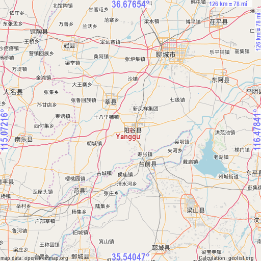
Yanggu GPS coordinates[2]
36° 6' 38.016" North, 115° 46' 31.008" East
| Map corner | latitude | longitude |
|---|---|---|
| Upper-left | 36.67654°, | 115.07216° |
| Center: | 36.11056°, | 115.77528° |
| Lower-right: | 35.54047°, | 116.47841° |
| Map W x H: | 126.3×126.3 km | = 78.5×78.5mi |
| max Lat: | 53.31946° ⇑22.5% North |
| Yanggu: | 36.11056° |
| min Lat: | ⇓77.5% South 18.22056° |
| min Long | Yanggu | max Long |
| 75.07348° | 115.77528° | 134.28917° |
| W 58.7%⇐ | ⇒41.3% E |
Elevation
Elevation of Yanggu is 42 m = 138 ft, and this is 442.8 m = 1453 ft below average elevation for this country.
| Max E: |
5622 m = 18445 ft | 73% |
| Avg. | 484.8 m = 1591 ft | |
| Yanggu | 42 m = 138 ft | |
Min E: |
-3 m = -10 ft | 27% |
See also: Yanggu elevation on elevation.city.
Geographical zone
Yanggu is located in North temperate zone (between Tropic of Cancer and the Arctic Circle). Distance of this Northern Tropic circle is 1409.2 km =875.6 mi to South.| Distance of | km | miles | from Yanggu |
|---|---|---|---|
| North Pole | 5991.9 | 3723.2 | to North |
| Arctic Circle | 3386.1 | 2104 | to North |
| Tropic Cancer | 1409.2 | 875.6 | to South |
| Equator | 4015.1 | 2494.9 | to South |


Nearby cities:
15 places around Yanggu: (largest is in red/bold)
• Daming
59.9 km =37.2 mi,  288°
288°
• Fan Xian Chengguanzhen
37.4 km =23.2 mi,  221°
221°
• Guancheng
51.2 km =31.8 mi,  323°
323°
• Guantao
65.1 km =40.5 mi, 317°
• Gulou
40.8 km =25.4 mi,  24°
24°
• Juancheng
65.8 km =40.9 mi,  202°
202°
• Liaocheng
42.5 km =26.4 mi,  25°
25°
• Nanle Chengguanzhen
51.9 km =32.2 mi,  265°
265°
• Pingyin
63.1 km =39.2 mi,  72°
72°
• Qingfeng Chengguanzhen
64.5 km =40.1 mi,  249°
249°
• Xiying
57.2 km =35.5 mi,  311°
311°
• Yangying
36.1 km =22.4 mi,  154°
154°
• Yanta
17.5 km =10.9 mi,  326°
326°
• Yuncheng
58.7 km =36.5 mi,  165°
165°
• Zhoucheng
53 km =32.9 mi,  114°
114°
Sources, notices
• [Note1] Compared only with cities in China existing in our database
• [Src1] Map data: © OpenStreetMap contributors (CC-BY-SA)
• [Src2] Other city data from geonames.org with taken over terms of usage.
• [Src3] Geographical zone / Annual Mean Temperature by Robert A. Rohde @ Wikipedia
