Changcun geodata
Changcun (Henan) is a seat of a fourth-order administrative division; located in China in Asia/Shanghai (GMT+8) time zone. In our database, there are 1268 cities with bigger population. Compared to other cities in China, 68.2% of cities are located further ↓South; 56.8% of cities are located further →East and 53.5% of cities have higher elevation than Changcun. Note1


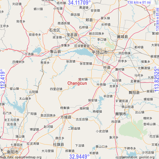
Changcun GPS coordinates[2]
33° 31' 58.728" North, 113° 7' 19.632" East
| Map corner | latitude | longitude |
|---|---|---|
| Upper-left | 34.11709°, | 112.419° |
| Center: | 33.53298°, | 113.12212° |
| Lower-right: | 32.9449°, | 113.82525° |
| Map W x H: | 130.3×130.3 km | = 81×81mi |
| max Lat: | 53.31946° ⇑31.8% North |
| Changcun: | 33.53298° |
| min Lat: | ⇓68.2% South 18.22056° |
| min Long | Changcun | max Long |
| 75.07348° | 113.12212° | 134.28917° |
| W 43.2%⇐ | ⇒56.8% E |
Elevation
Elevation of Changcun is 140 m = 459 ft, and this is 344.8 m = 1131 ft below average elevation for this country.
| Max E: |
5622 m = 18445 ft | 53.5% |
| Avg. | 484.8 m = 1591 ft | |
| Changcun | 140 m = 459 ft | |
Min E: |
-3 m = -10 ft | 46.5% |
See also: China elevation on elevation.city.
Geographical zone
Changcun is located in North temperate zone (between Tropic of Cancer and the Arctic Circle). Distance of this Northern Tropic circle is 1122.6 km =697.6 mi to South.| Distance of | km | miles | from Changcun |
|---|---|---|---|
| North Pole | 6278.5 | 3901.3 | to North |
| Arctic Circle | 3672.7 | 2282.1 | to North |
| Tropic Cancer | 1122.6 | 697.6 | to South |
| Equator | 3728.5 | 2316.8 | to South |


Nearby cities:
15 places around Changcun: (largest is in red/bold)
• Bao’an
19.7 km =12.2 mi,  147°
147°
• Beidu
24.7 km =15.3 mi,  38°
38°
• Caozhen
20.9 km =13 mi,  24°
24°
• Dushu
23.3 km =14.5 mi,  171°
171°
• Gunziying
15.3 km =9.5 mi,  353°
353°
• Jiuxian
17 km =10.6 mi,  104°
104°
• Kunyang
22.8 km =14.2 mi,  64°
64°
• Malou
20.6 km =12.8 mi,  322°
322°
• Mazhuang
21.5 km =13.4 mi,  72°
72°
• Rendian
14.3 km =8.9 mi, 43°
• Silidian
20.5 km =12.7 mi,  248°
248°
• Tianzhuang
21.8 km =13.5 mi,  79°
79°
• Xiali
8.4 km =5.2 mi,  91°
91°
• Zhangguanying
14.3 km =8.9 mi, 19°
• Zhangliang
17 km =10.6 mi,  333°
333°
Sources, notices
• [Note1] Compared only with cities in China existing in our database
• [Src1] Map data: © OpenStreetMap contributors (CC-BY-SA)
• [Src2] Other city data from geonames.org with taken over terms of usage.
• [Src3] Geographical zone / Annual Mean Temperature by Robert A. Rohde @ Wikipedia
