Xinshichang geodata
Xinshichang (Zhejiang) is a seat of a fourth-order administrative division; located in China in Asia/Shanghai (GMT+8) time zone. In our database, there are 1268 cities with bigger population. Compared to other cities in China, 62.3% of cities are located further ↑North; 86.9% of cities are located further ←West and 70.9% of cities have lower elevation than Xinshichang. Note1


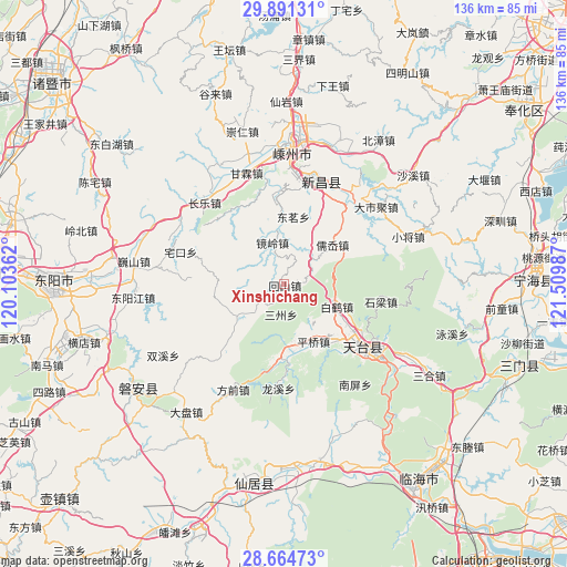
Xinshichang GPS coordinates[2]
29° 16' 47.496" North, 120° 48' 24.264" East
| Map corner | latitude | longitude |
|---|---|---|
| Upper-left | 29.89131°, | 120.10362° |
| Center: | 29.27986°, | 120.80674° |
| Lower-right: | 28.66473°, | 121.50987° |
| Map W x H: | 136.4×136.4 km | = 84.8×84.8mi |
| max Lat: | 53.31946° ⇑62.3% North |
| Xinshichang: | 29.27986° |
| min Lat: | ⇓37.7% South 18.22056° |
| min Long | Xinshichang | max Long |
| 75.07348° | 120.80674° | 134.28917° |
| W 86.9%⇐ | ⇒13.1% E |
Elevation
Elevation of Xinshichang is 428 m = 1404 ft, and this is 56.8 m = 186 ft below average elevation for this country.
| Max E: |
5622 m = 18445 ft | 29.1% |
| Avg. | 484.8 m = 1591 ft | |
| Xinshichang | 428 m = 1404 ft | |
Min E: |
-3 m = -10 ft | 70.9% |
See also: China elevation on elevation.city.
Geographical zone
Xinshichang is located in North temperate zone (between Tropic of Cancer and the Arctic Circle). Distance of this Northern Tropic circle is 649.7 km =403.7 mi to South.| Distance of | km | miles | from Xinshichang |
|---|---|---|---|
| North Pole | 6751.4 | 4195.1 | to North |
| Arctic Circle | 4145.6 | 2576 | to North |
| Tropic Cancer | 649.7 | 403.7 | to South |
| Equator | 3255.6 | 2022.9 | to South |


Nearby cities:
15 places around Xinshichang: (largest is in red/bold)
• Baihedian
13.4 km =8.3 mi,  111°
111°
• Changle
27.3 km =17 mi,  315°
315°
• Chengtan
18.8 km =11.7 mi,  355°
355°
• Dianqian
7 km =4.3 mi,  339°
339°
• Diji
17.1 km =10.6 mi,  277°
277°
• Jianshan
10.7 km =6.6 mi,  235°
235°
• Jietou
18.2 km =11.3 mi,  180°
180°
• Jingling
10.7 km =6.6 mi,  347°
347°
• Meizhu
22 km =13.7 mi, 357°
• Pingqiao
15.9 km =9.9 mi,  153°
153°
• Ru’ao
13.9 km =8.6 mi,  50°
50°
• Shanghu
20.9 km =13 mi,  225°
225°
• Shiliang
23.3 km =14.5 mi,  100°
100°
• Tiantai Chengguanzhen
26.9 km =16.7 mi,  126°
126°
• Xinchang Chengguanzhen
26.6 km =16.5 mi,  19°
19°
Sources, notices
• [Note1] Compared only with cities in China existing in our database
• [Src1] Map data: © OpenStreetMap contributors (CC-BY-SA)
• [Src2] Other city data from geonames.org with taken over terms of usage.
• [Src3] Geographical zone / Annual Mean Temperature by Robert A. Rohde @ Wikipedia
