Baihedian geodata
Baihedian (Zhejiang) is a seat of a fourth-order administrative division; located in China in Asia/Shanghai (GMT+8) time zone. In our database, there are 1268 cities with bigger population. Compared to other cities in China, 62.9% of cities are located further ↑North; 87.5% of cities are located further ←West and 56.9% of cities have higher elevation than Baihedian. Note1


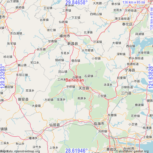
Baihedian GPS coordinates[2]
29° 14' 5.496" North, 120° 56' 6.54" East
| Map corner | latitude | longitude |
|---|---|---|
| Upper-left | 29.84658°, | 120.23203° |
| Center: | 29.23486°, | 120.93515° |
| Lower-right: | 28.61946°, | 121.63828° |
| Map W x H: | 136.4×136.4 km | = 84.8×84.8mi |
| max Lat: | 53.31946° ⇑62.9% North |
| Baihedian: | 29.23486° |
| min Lat: | ⇓37.1% South 18.22056° |
| min Long | Baihedian | max Long |
| 75.07348° | 120.93515° | 134.28917° |
| W 87.5%⇐ | ⇒12.5% E |
Elevation
Elevation of Baihedian is 118 m = 387 ft, and this is 366.8 m = 1203 ft below average elevation for this country.
| Max E: |
5622 m = 18445 ft | 56.9% |
| Avg. | 484.8 m = 1591 ft | |
| Baihedian | 118 m = 387 ft | |
Min E: |
-3 m = -10 ft | 43.1% |
See also: China elevation on elevation.city.
Geographical zone
Baihedian is located in North temperate zone (between Tropic of Cancer and the Arctic Circle). Distance of this Northern Tropic circle is 644.7 km =400.6 mi to South.| Distance of | km | miles | from Baihedian |
|---|---|---|---|
| North Pole | 6756.5 | 4198.3 | to North |
| Arctic Circle | 4150.6 | 2579.1 | to North |
| Tropic Cancer | 644.7 | 400.6 | to South |
| Equator | 3250.6 | 2019.8 | to South |


Nearby cities:
15 places around Baihedian: (largest is in red/bold)
• Chengtan
27.6 km =17.1 mi,  329°
329°
• Dashiju
25.2 km =15.7 mi,  22°
22°
• Dianqian
18.9 km =11.7 mi,  307°
307°
• Huangwu
28 km =17.4 mi,  126°
126°
• Jianshan
21.3 km =13.2 mi,  267°
267°
• Jietou
18.4 km =11.4 mi,  223°
223°
• Jingling
21.3 km =13.2 mi,  316°
316°
• Pingqiao
10.6 km =6.6 mi,  209°
209°
• Ru’ao
14 km =8.7 mi,  352°
352°
• Shanghu
29 km =18 mi,  250°
250°
• Shiliang
10.5 km =6.5 mi,  86°
86°
• Tantou
22.5 km =14 mi, 127°
• Tiantai Chengguanzhen
14.3 km =8.9 mi,  140°
140°
• Xiaojiang
24 km =14.9 mi,  46°
46°
• Xinshichang
13.4 km =8.3 mi,  291°
291°
Sources, notices
• [Note1] Compared only with cities in China existing in our database
• [Src1] Map data: © OpenStreetMap contributors (CC-BY-SA)
• [Src2] Other city data from geonames.org with taken over terms of usage.
• [Src3] Geographical zone / Annual Mean Temperature by Robert A. Rohde @ Wikipedia
