Huarong Chengguanzhen geodata
Huarong Chengguanzhen (Hunan) is a seat of a third-order administrative division; located in China in Asia/Shanghai (GMT+8) time zone. In our database, there are 1268 cities with bigger population. Compared to other cities in China, 59.5% of cities are located further ↑North; 59.8% of cities are located further →East and 79.8% of cities have higher elevation than Huarong Chengguanzhen. Note1


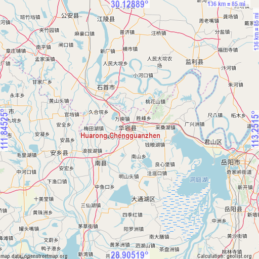
Huarong Chengguanzhen GPS coordinates[2]
29° 31' 8.004" North, 112° 32' 54.132" East
| Map corner | latitude | longitude |
|---|---|---|
| Upper-left | 30.12889°, | 111.84525° |
| Center: | 29.51889°, | 112.54837° |
| Lower-right: | 28.90519°, | 113.2515° |
| Map W x H: | 136.1×136.1 km | = 84.6×84.6mi |
| max Lat: | 53.31946° ⇑59.5% North |
| Huarong Chengguanzhen: | 29.51889° |
| min Lat: | ⇓40.5% South 18.22056° |
| min Long | Huarong Chenggu | max Long |
| 75.07348° | 112.54837° | 134.28917° |
| W 40.2%⇐ | ⇒59.8% E |
Elevation
Elevation of Huarong Chengguanzhen is 27 m = 89 ft, and this is 457.8 m = 1502 ft below average elevation for this country.
| Max E: |
5622 m = 18445 ft | 79.8% |
| Avg. | 484.8 m = 1591 ft | |
| Huarong Chengguanzhen | 27 m = 89 ft | |
Min E: |
-3 m = -10 ft | 20.2% |
See also: China elevation on elevation.city.
Geographical zone
Huarong Chengguanzhen is located in North temperate zone (between Tropic of Cancer and the Arctic Circle). Distance of this Northern Tropic circle is 676.3 km =420.2 mi to South.| Distance of | km | miles | from Huarong Chengguanzhen |
|---|---|---|---|
| North Pole | 6724.9 | 4178.7 | to North |
| Arctic Circle | 4119 | 2559.4 | to North |
| Tropic Cancer | 676.3 | 420.2 | to South |
| Equator | 3282.2 | 2039.5 | to South |


Nearby cities:
15 places around Huarong Chengguanzhen: (largest is in red/bold)
• Diaoguan
20.6 km =12.8 mi,  21°
21°
• Dongsheng
22.1 km =13.7 mi,  353°
353°
• Gaojimiao
18.1 km =11.2 mi,  319°
319°
• Gaoling
33.2 km =20.6 mi, 316°
• Huage
26.8 km =16.7 mi,  156°
156°
• Jiaoshanhe
15.3 km =9.5 mi,  6°
6°
• Jiuheyuan
19 km =11.8 mi,  300°
300°
• Meitianhu
18 km =11.2 mi,  271°
271°
• Nanzhou
22.7 km =14.1 mi,  218°
218°
• Taohuashan
20.2 km =12.6 mi,  41°
41°
• Tuanshansi
24.3 km =15.1 mi,  293°
293°
• Tuanzhou
30 km =18.6 mi,  133°
133°
• Xiaohekou
29.7 km =18.5 mi, 13°
• Xinhe
10.6 km =6.6 mi,  195°
195°
• Xiulin
26.3 km =16.3 mi,  326°
326°
Sources, notices
• [Note1] Compared only with cities in China existing in our database
• [Src1] Map data: © OpenStreetMap contributors (CC-BY-SA)
• [Src2] Other city data from geonames.org with taken over terms of usage.
• [Src3] Geographical zone / Annual Mean Temperature by Robert A. Rohde @ Wikipedia
