Jiaojiang geodata
Jiaojiang (Zhejiang) is a section of populated place; located in China in Asia/Shanghai (GMT+8) time zone. With population of 470,804 people, there are 134 cities with bigger population in this country. Compared to other cities in China, 68% of cities are located further ↑North; 89.9% of cities are located further ←West and 89.9% of cities have higher elevation than Jiaojiang. Note1


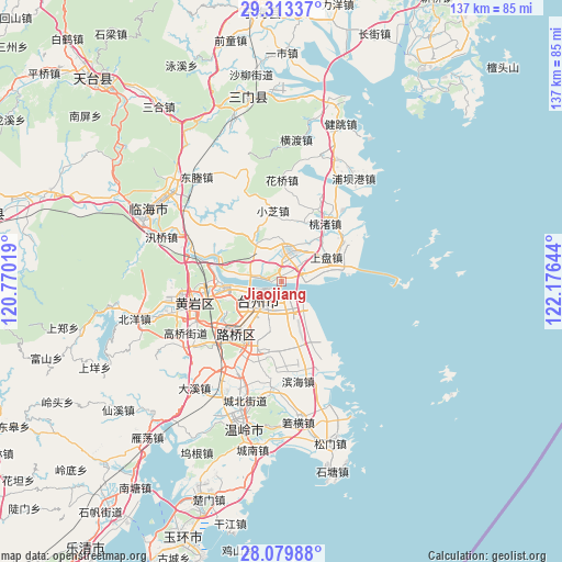
Jiaojiang GPS coordinates[2]
28° 41' 54.384" North, 121° 28' 23.916" East
| Map corner | latitude | longitude |
|---|---|---|
| Upper-left | 29.31337°, | 120.77019° |
| Center: | 28.69844°, | 121.47331° |
| Lower-right: | 28.07988°, | 122.17644° |
| Map W x H: | 137.2×137.2 km | = 85.3×85.3mi |
| max Lat: | 53.31946° ⇑68% North |
| Jiaojiang: | 28.69844° |
| min Lat: | ⇓32% South 18.22056° |
| min Long | Jiaojiang | max Long |
| 75.07348° | 121.47331° | 134.28917° |
| W 89.9%⇐ | ⇒10.1% E |
Elevation
Elevation of Jiaojiang is 10 m = 33 ft, and this is 474.8 m = 1558 ft below average elevation for this country.
| Max E: |
5622 m = 18445 ft | 89.9% |
| Avg. | 484.8 m = 1591 ft | |
| Jiaojiang | 10 m = 33 ft | |
Min E: |
-3 m = -10 ft | 10.1% |
See also: Jiaojiang elevation on elevation.city.
Geographical zone
Jiaojiang is located in North temperate zone (between Tropic of Cancer and the Arctic Circle). Distance of this Northern Tropic circle is 585 km =363.5 mi to South.| Distance of | km | miles | from Jiaojiang |
|---|---|---|---|
| North Pole | 6816.1 | 4235.3 | to North |
| Arctic Circle | 4210.2 | 2616.1 | to North |
| Tropic Cancer | 585 | 363.5 | to South |
| Equator | 3191 | 1982.8 | to South |


Nearby cities:
15 places around Jiaojiang: (largest is in red/bold)
• Baiyun
6.9 km =4.3 mi,  251°
251°
• Duqiao
8 km =5 mi,  12°
12°
• Haimen
5.2 km =3.2 mi, 247°
• Hongjia
11.1 km =6.9 mi,  212°
212°
• Jiangkou
15.3 km =9.5 mi,  261°
261°
• Jiazhi
9.7 km =6 mi, 253°
• Lubei
16 km =9.9 mi,  218°
218°
• Luqiao
16.3 km =10.1 mi, 216°
• Pengjie
15.9 km =9.9 mi,  177°
177°
• Qiansuo
2.6 km =1.6 mi,  271°
271°
• Sanjia
9.4 km =5.8 mi, 179°
• Taizhou
5.6 km =3.5 mi, 224°
• Xiachen
12.3 km =7.6 mi,  190°
190°
• Yongquan
16.8 km =10.4 mi,  295°
295°
• Zhang’an
6.4 km =4 mi,  286°
286°
Sources, notices
• [Note1] Compared only with cities in China existing in our database
• [Src1] Map data: © OpenStreetMap contributors (CC-BY-SA)
• [Src2] Other city data from geonames.org with taken over terms of usage.
• [Src3] Geographical zone / Annual Mean Temperature by Robert A. Rohde @ Wikipedia
