Guangze geodata
Guangze (Fujian) is a seat of a third-order administrative division; located in China in Asia/Shanghai (GMT+8) time zone. In our database, there are 1268 cities with bigger population. Compared to other cities in China, 76.5% of cities are located further ↑North; 68% of cities are located further ←West and 56.9% of cities have lower elevation than Guangze. Note1


Guangze GPS coordinates[2]
27° 32' 36.492" North, 117° 19' 53.796" East
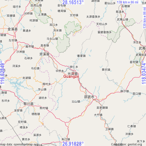
| Map corner | latitude | longitude |
|---|---|---|
| Upper-left | 28.16513°, | 116.62849° |
| Center: | 27.54347°, | 117.33161° |
| Lower-right: | 26.91828°, | 118.03474° |
| Map W x H: | 138.6×138.6 km | = 86.1×86.1mi |
| max Lat: | 53.31946° ⇑76.5% North |
| Guangze: | 27.54347° |
| min Lat: | ⇓23.5% South 18.22056° |
| min Long | Guangze | max Long |
| 75.07348° | 117.33161° | 134.28917° |
| W 68%⇐ | ⇒32% E |
Elevation
Elevation of Guangze is 225 m = 738 ft, and this is 259.8 m = 852 ft below average elevation for this country.
| Max E: |
5622 m = 18445 ft | 43.1% |
| Avg. | 484.8 m = 1591 ft | |
| Guangze | 225 m = 738 ft | |
Min E: |
-3 m = -10 ft | 56.9% |
See also: China elevation on elevation.city.
Geographical zone
Guangze is located in North temperate zone (between Tropic of Cancer and the Arctic Circle). Distance of this Northern Tropic circle is 456.6 km =283.7 mi to South.| Distance of | km | miles | from Guangze |
|---|---|---|---|
| North Pole | 6944.5 | 4315.1 | to North |
| Arctic Circle | 4338.6 | 2695.9 | to North |
| Tropic Cancer | 456.6 | 283.7 | to South |
| Equator | 3062.5 | 1902.9 | to South |


Nearby cities:
15 places around Guangze: (largest is in red/bold)
• Chenfang
60.2 km =37.4 mi,  19°
19°
• Erkou
49.6 km =30.8 mi,  338°
338°
• Gaotian
53.5 km =33.2 mi,  297°
297°
• Hongmen
61.5 km =38.2 mi,  264°
264°
• Lengshui
43.1 km =26.8 mi, 340°
• Rifeng
49.7 km =30.9 mi,  236°
236°
• Shaowu
27 km =16.8 mi,  146°
146°
• Shazhou
53.9 km =33.5 mi,  292°
292°
• Shixia
44.7 km =27.8 mi, 288°
• Songshi
48.4 km =30.1 mi, 301°
• Taiyuan
54.6 km =33.9 mi, 18°
• Tangwan
60.2 km =37.4 mi,  349°
349°
• Tanxi
48.1 km =29.9 mi,  233°
233°
• Wenfang
55.1 km =34.2 mi,  0°
0°
• Zhangping
51.2 km =31.8 mi,  9°
9°
Sources, notices
• [Note1] Compared only with cities in China existing in our database
• [Src1] Map data: © OpenStreetMap contributors (CC-BY-SA)
• [Src2] Other city data from geonames.org with taken over terms of usage.
• [Src3] Geographical zone / Annual Mean Temperature by Robert A. Rohde @ Wikipedia
