Guiping geodata
Guiping (Guangxi) is a seat of a third-order administrative division; located in China in Asia/Shanghai (GMT+8) time zone. With population of 71,066 people, there are 603 cities with bigger population in this country. Compared to other cities in China, 92.7% of cities are located further ↑North; 70.9% of cities are located further →East and 72.3% of cities have higher elevation than Guiping. Note1


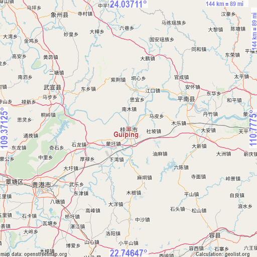
Guiping GPS coordinates[2]
23° 23' 36.096" North, 110° 4' 27.732" East
| Map corner | latitude | longitude |
|---|---|---|
| Upper-left | 24.03711°, | 109.37125° |
| Center: | 23.39336°, | 110.07437° |
| Lower-right: | 22.74647°, | 110.7775° |
| Map W x H: | 143.5×143.5 km | = 89.2×89.2mi |
| max Lat: | 53.31946° ⇑92.7% North |
| Guiping: | 23.39336° |
| min Lat: | ⇓7.3% South 18.22056° |
| min Long | Guiping | max Long |
| 75.07348° | 110.07437° | 134.28917° |
| W 29.1%⇐ | ⇒70.9% E |
Elevation
Elevation of Guiping is 44 m = 144 ft, and this is 440.8 m = 1446 ft below average elevation for this country.
| Max E: |
5622 m = 18445 ft | 72.3% |
| Avg. | 484.8 m = 1591 ft | |
| Guiping | 44 m = 144 ft | |
Min E: |
-3 m = -10 ft | 27.7% |
See also: Guiping elevation on elevation.city.
Geographical zone
Guiping is located in North Torrid zone (between Equator and Tropic of Cancer). Distance of this Northern Tropic circle is 4.8 km =3 mi to North.| Distance of | km | miles | from Guiping |
|---|---|---|---|
| North Pole | 7406 | 4601.9 | to North |
| Arctic Circle | 4800.1 | 2982.6 | to North |
| Tropic Cancer | 4.8 | 3 | to North |
| Equator | 2601.1 | 1616.2 | to South |


Nearby cities:
15 places around Guiping: (largest is in red/bold)
• Guigang
57.9 km =36 mi,  235°
235°
• Jinji
78.9 km =49 mi,  103°
103°
• Jinxiu
83.4 km =51.8 mi,  7°
7°
• Laibin
89.1 km =55.4 mi,  292°
292°
• Lingcheng
81.3 km =50.5 mi,  159°
159°
• Nandu
97.4 km =60.5 mi,  128°
128°
• Pingnan
36.1 km =22.4 mi,  62°
62°
• Qiaoxu
58.2 km =36.2 mi,  213°
213°
• Rongcheng
76.6 km =47.6 mi,  140°
140°
• Shinan
75.1 km =46.7 mi,  195°
195°
• Tantang
73.3 km =45.5 mi,  247°
247°
• Tengzhou
83.4 km =51.8 mi,  90°
90°
• Wuxuan
50.2 km =31.2 mi,  300°
300°
• Xiangzhou
76.6 km =47.6 mi,  327°
327°
• Yulin
84.9 km =52.8 mi,  174°
174°
Sources, notices
• [Note1] Compared only with cities in China existing in our database
• [Src1] Map data: © OpenStreetMap contributors (CC-BY-SA)
• [Src2] Other city data from geonames.org with taken over terms of usage.
• [Src3] Geographical zone / Annual Mean Temperature by Robert A. Rohde @ Wikipedia
