Kangle geodata
Kangle (Chongqing) is a seat of a fourth-order administrative division; located in China in Asia/Shanghai (GMT+8) time zone. In our database, there are 1268 cities with bigger population. Compared to other cities in China, 55.6% of cities are located further ↓South; 74.3% of cities are located further →East and 53.1% of cities have lower elevation than Kangle. Note1


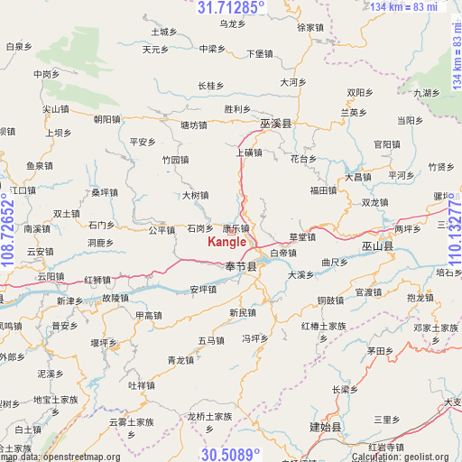
Kangle GPS coordinates[2]
31° 6' 46.008" North, 109° 25' 46.704" East
| Map corner | latitude | longitude |
|---|---|---|
| Upper-left | 31.71285°, | 108.72652° |
| Center: | 31.11278°, | 109.42964° |
| Lower-right: | 30.5089°, | 110.13277° |
| Map W x H: | 133.9×133.9 km | = 83.2×83.2mi |
| max Lat: | 53.31946° ⇑44.4% North |
| Kangle: | 31.11278° |
| min Lat: | ⇓55.6% South 18.22056° |
| min Long | Kangle | max Long |
| 75.07348° | 109.42964° | 134.28917° |
| W 25.7%⇐ | ⇒74.3% E |
Elevation
Elevation of Kangle is 189 m = 620 ft, and this is 295.8 m = 970 ft below average elevation for this country.
| Max E: |
5622 m = 18445 ft | 46.9% |
| Avg. | 484.8 m = 1591 ft | |
| Kangle | 189 m = 620 ft | |
Min E: |
-3 m = -10 ft | 53.1% |
See also: China elevation on elevation.city.
Geographical zone
Kangle is located in North temperate zone (between Tropic of Cancer and the Arctic Circle). Distance of this Northern Tropic circle is 853.5 km =530.3 mi to South.| Distance of | km | miles | from Kangle |
|---|---|---|---|
| North Pole | 6547.6 | 4068.5 | to North |
| Arctic Circle | 3941.8 | 2449.3 | to North |
| Tropic Cancer | 853.5 | 530.3 | to South |
| Equator | 3459.4 | 2149.6 | to South |


Nearby cities:
15 places around Kangle: (largest is in red/bold)
• Anping
18.4 km =11.4 mi,  205°
205°
• Baidi
16.5 km =10.3 mi,  111°
111°
• Caotang
18.7 km =11.6 mi,  97°
97°
• Dashu
15 km =9.3 mi,  316°
316°
• Daxi
23.5 km =14.6 mi,  122°
122°
• Fenhe
9.2 km =5.7 mi,  72°
72°
• Gongping
22.2 km =13.8 mi,  274°
274°
• Gulu
24.2 km =15 mi,  2°
2°
• Kangping
23.1 km =14.4 mi,  229°
229°
• Shanghuang
23.7 km =14.7 mi,  12°
12°
• Shigang
6.7 km =4.2 mi,  292°
292°
• Xinmin
23.5 km =14.6 mi,  171°
171°
• Yanwan
13.3 km =8.3 mi,  46°
46°
• Yongle
13.4 km =8.3 mi,  147°
147°
• Yong’an
10.6 km =6.6 mi,  164°
164°
Sources, notices
• [Note1] Compared only with cities in China existing in our database
• [Src1] Map data: © OpenStreetMap contributors (CC-BY-SA)
• [Src2] Other city data from geonames.org with taken over terms of usage.
• [Src3] Geographical zone / Annual Mean Temperature by Robert A. Rohde @ Wikipedia
