Anping geodata
Anping (Chongqing) is a seat of a fourth-order administrative division; located in China in Asia/Shanghai (GMT+8) time zone. In our database, there are 1268 cities with bigger population. Compared to other cities in China, 54.5% of cities are located further ↓South; 74.7% of cities are located further →East and 57.8% of cities have lower elevation than Anping. Note1


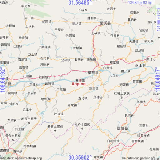
Anping GPS coordinates[2]
30° 57' 49.824" North, 109° 20' 42.144" East
| Map corner | latitude | longitude |
|---|---|---|
| Upper-left | 31.56485°, | 108.64192° |
| Center: | 30.96384°, | 109.34504° |
| Lower-right: | 30.35902°, | 110.04817° |
| Map W x H: | 134.1×134.1 km | = 83.3×83.3mi |
| max Lat: | 53.31946° ⇑45.5% North |
| Anping: | 30.96384° |
| min Lat: | ⇓54.5% South 18.22056° |
| min Long | Anping | max Long |
| 75.07348° | 109.34504° | 134.28917° |
| W 25.3%⇐ | ⇒74.7% E |
Elevation
Elevation of Anping is 234 m = 768 ft, and this is 250.8 m = 823 ft below average elevation for this country.
| Max E: |
5622 m = 18445 ft | 42.2% |
| Avg. | 484.8 m = 1591 ft | |
| Anping | 234 m = 768 ft | |
Min E: |
-3 m = -10 ft | 57.8% |
See also: China elevation on elevation.city.
Geographical zone
Anping is located in North temperate zone (between Tropic of Cancer and the Arctic Circle). Distance of this Northern Tropic circle is 836.9 km =520 mi to South.| Distance of | km | miles | from Anping |
|---|---|---|---|
| North Pole | 6564.2 | 4078.8 | to North |
| Arctic Circle | 3958.3 | 2459.6 | to North |
| Tropic Cancer | 836.9 | 520 | to South |
| Equator | 3442.9 | 2139.3 | to South |


Nearby cities:
15 places around Anping: (largest is in red/bold)
• Chang’an
25.1 km =15.6 mi,  126°
126°
• Fengping
20.9 km =13 mi, 133°
• Fenhe
25.6 km =15.9 mi,  41°
41°
• Gongping
23 km =14.3 mi,  322°
322°
• Guling
25.4 km =15.8 mi,  264°
264°
• Jiagao
18.1 km =11.2 mi,  242°
242°
• Kangle
18.4 km =11.4 mi,  25°
25°
• Kangping
9.7 km =6 mi,  279°
279°
• Longdong
17.1 km =10.6 mi,  273°
273°
• Qinglong
22.1 km =13.7 mi,  202°
202°
• Shigang
19.2 km =11.9 mi,  5°
5°
• Wuma
12.6 km =7.8 mi,  166°
166°
• Xinmin
13.4 km =8.3 mi,  120°
120°
• Yongle
16.1 km =10 mi,  71°
71°
• Yong’an
12.5 km =7.8 mi,  59°
59°
Sources, notices
• [Note1] Compared only with cities in China existing in our database
• [Src1] Map data: © OpenStreetMap contributors (CC-BY-SA)
• [Src2] Other city data from geonames.org with taken over terms of usage.
• [Src3] Geographical zone / Annual Mean Temperature by Robert A. Rohde @ Wikipedia
