Zunhua geodata
Zunhua (Hebei) is a seat of a third-order administrative division; located in China in Asia/Shanghai (GMT+8) time zone. In our database, there are 1268 cities with bigger population. Compared to other cities in China, 87.1% of cities are located further ↓South; 70.4% of cities are located further ←West and 70% of cities have higher elevation than Zunhua. Note1


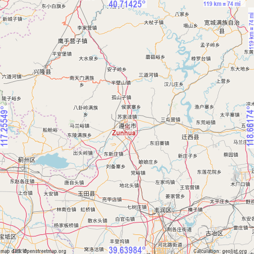
Zunhua GPS coordinates[2]
40° 10' 45.012" North, 117° 57' 30.996" East
| Map corner | latitude | longitude |
|---|---|---|
| Upper-left | 40.71425°, | 117.25549° |
| Center: | 40.17917°, | 117.95861° |
| Lower-right: | 39.63984°, | 118.66174° |
| Map W x H: | 119.5×119.5 km | = 74.3×74.3mi |
| max Lat: | 53.31946° ⇑12.9% North |
| Zunhua: | 40.17917° |
| min Lat: | ⇓87.1% South 18.22056° |
| min Long | Zunhua | max Long |
| 75.07348° | 117.95861° | 134.28917° |
| W 70.4%⇐ | ⇒29.6% E |
Elevation
Elevation of Zunhua is 52 m = 171 ft, and this is 432.8 m = 1420 ft below average elevation for this country.
| Max E: |
5622 m = 18445 ft | 70% |
| Avg. | 484.8 m = 1591 ft | |
| Zunhua | 52 m = 171 ft | |
Min E: |
-3 m = -10 ft | 30% |
See also: China elevation on elevation.city.
Geographical zone
Zunhua is located in North temperate zone (between Tropic of Cancer and the Arctic Circle). Distance of this Northern Tropic circle is 1861.6 km =1156.7 mi to South.| Distance of | km | miles | from Zunhua |
|---|---|---|---|
| North Pole | 5539.6 | 3442.1 | to North |
| Arctic Circle | 2933.7 | 1822.9 | to North |
| Tropic Cancer | 1861.6 | 1156.7 | to South |
| Equator | 4467.5 | 2776 | to South |


Nearby cities:
15 places around Zunhua: (largest is in red/bold)
• Dabao’anzhen
51.5 km =32 mi,  232°
232°
• Dahengshang
54.5 km =33.9 mi, 226°
• Dongzhaogezhuang
56.3 km =35 mi,  242°
242°
• Fengrun
40.7 km =25.3 mi,  160°
160°
• Jinhaihu
58.2 km =36.2 mi,  270°
270°
• Lizhuangzi
59.5 km =37 mi,  248°
248°
• Mengquan
56.9 km =35.4 mi, 226°
• Shangcang
57.7 km =35.9 mi, 237°
• Songling
29.2 km =18.1 mi,  64°
64°
• Xinglong
46.7 km =29 mi,  305°
305°
• Yangezhuang
30.6 km =19 mi, 228°
• Yangjinzhuang
57.9 km =36 mi, 235°
• Yingshouyingzi
48.4 km =30.1 mi,  328°
328°
• Yinliu
52.6 km =32.7 mi, 245°
• Yutian
38.3 km =23.8 mi,  209°
209°
Sources, notices
• [Note1] Compared only with cities in China existing in our database
• [Src1] Map data: © OpenStreetMap contributors (CC-BY-SA)
• [Src2] Other city data from geonames.org with taken over terms of usage.
• [Src3] Geographical zone / Annual Mean Temperature by Robert A. Rohde @ Wikipedia
