Xinyi geodata
Xinyi (Guangdong) is a populated place; located in China in Asia/Urumqi (GMT+6) time zone. With population of 98,259 people, there are 433 cities with bigger population in this country. Compared to other cities in China, 96.6% of cities are located further ↑North; 67.2% of cities are located further →East and 61.7% of cities have higher elevation than Xinyi. Note1


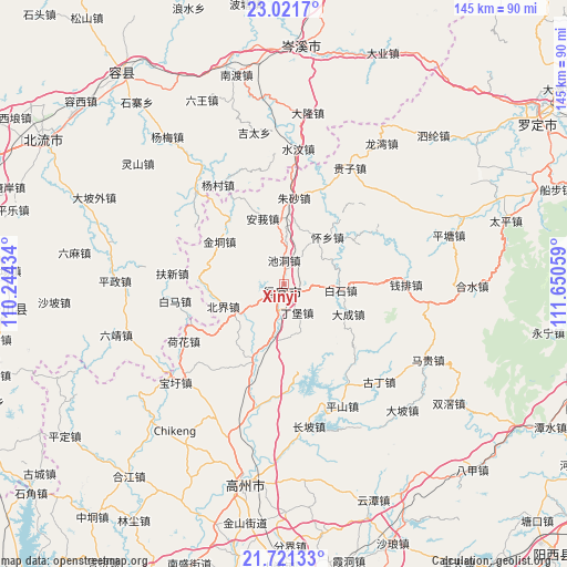
Xinyi GPS coordinates[2]
22° 22' 22.908" North, 110° 56' 50.856" East
| Map corner | latitude | longitude |
|---|---|---|
| Upper-left | 23.0217°, | 110.24434° |
| Center: | 22.37303°, | 110.94746° |
| Lower-right: | 21.72133°, | 111.65059° |
| Map W x H: | 144.6×144.6 km | = 89.9×89.9mi |
| max Lat: | 53.31946° ⇑96.6% North |
| Xinyi: | 22.37303° |
| min Lat: | ⇓3.4% South 18.22056° |
| min Long | Xinyi | max Long |
| 75.07348° | 110.94746° | 134.28917° |
| W 32.8%⇐ | ⇒67.2% E |
Elevation
Elevation of Xinyi is 89 m = 292 ft, and this is 395.8 m = 1299 ft below average elevation for this country.
| Max E: |
5622 m = 18445 ft | 61.7% |
| Avg. | 484.8 m = 1591 ft | |
| Xinyi | 89 m = 292 ft | |
Min E: |
-3 m = -10 ft | 38.3% |
See also: Xinyi elevation on elevation.city.
Geographical zone
Xinyi is located in North Torrid zone (between Equator and Tropic of Cancer). Distance of this Northern Tropic circle is 118.3 km =73.5 mi to North.| Distance of | km | miles | from Xinyi |
|---|---|---|---|
| North Pole | 7519.4 | 4672.3 | to North |
| Arctic Circle | 4913.5 | 3053.1 | to North |
| Tropic Cancer | 118.3 | 73.5 | to North |
| Equator | 2487.6 | 1545.7 | to South |


Nearby cities:
15 places around Xinyi: (largest is in red/bold)
• Baishi
15.1 km =9.4 mi,  96°
96°
• Beijie
16.4 km =10.2 mi,  248°
248°
• Chashan
28.5 km =17.7 mi,  43°
43°
• Chidong
6.1 km =3.8 mi,  359°
359°
• Dacheng
18.3 km =11.4 mi,  117°
117°
• Dingbao
8.4 km =5.2 mi,  160°
160°
• Dongzhen
1.2 km =0.7 mi,  309°
309°
• Dong’an
27.1 km =16.8 mi,  179°
179°
• Hongguan
22.2 km =13.8 mi,  66°
66°
• Jindong
19.8 km =12.3 mi,  300°
300°
• Shenzhen
27.5 km =17.1 mi,  140°
140°
• Shuikou
14.1 km =8.8 mi,  194°
194°
• Tantou
23 km =14.3 mi,  203°
203°
• Zhenlong
19.5 km =12.1 mi, 202°
• Zhusha
21.5 km =13.4 mi,  5°
5°
Sources, notices
• [Note1] Compared only with cities in China existing in our database
• [Src1] Map data: © OpenStreetMap contributors (CC-BY-SA)
• [Src2] Other city data from geonames.org with taken over terms of usage.
• [Src3] Geographical zone / Annual Mean Temperature by Robert A. Rohde @ Wikipedia
