Shenzhen geodata
Shenzhen (Guangdong) is a seat of a fourth-order administrative division; located in China in Asia/Urumqi (GMT+6) time zone. In our database, there are 1268 cities with bigger population. Compared to other cities in China, 97% of cities are located further ↑North; 66.6% of cities are located further →East and 60.3% of cities have lower elevation than Shenzhen. Note1


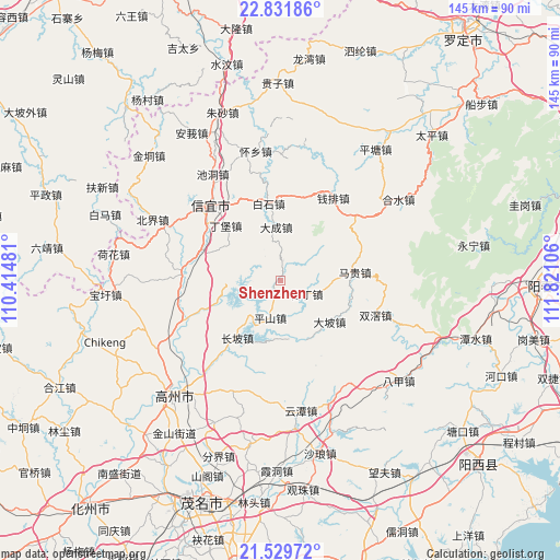
Shenzhen GPS coordinates[2]
22° 10' 56.28" North, 111° 7' 4.548" East
| Map corner | latitude | longitude |
|---|---|---|
| Upper-left | 22.83186°, | 110.41481° |
| Center: | 22.1823°, | 111.11793° |
| Lower-right: | 21.52972°, | 111.82106° |
| Map W x H: | 144.8×144.8 km | = 90×90mi |
| max Lat: | 53.31946° ⇑97% North |
| Shenzhen: | 22.1823° |
| min Lat: | ⇓3% South 18.22056° |
| min Long | Shenzhen | max Long |
| 75.07348° | 111.11793° | 134.28917° |
| W 33.4%⇐ | ⇒66.6% E |
Elevation
Elevation of Shenzhen is 263 m = 863 ft, and this is 221.8 m = 728 ft below average elevation for this country.
| Max E: |
5622 m = 18445 ft | 39.7% |
| Avg. | 484.8 m = 1591 ft | |
| Shenzhen | 263 m = 863 ft | |
Min E: |
-3 m = -10 ft | 60.3% |
See also: China elevation on elevation.city.
Geographical zone
Shenzhen is located in North Torrid zone (between Equator and Tropic of Cancer). Distance of this Northern Tropic circle is 139.5 km =86.7 mi to North.| Distance of | km | miles | from Shenzhen |
|---|---|---|---|
| North Pole | 7540.6 | 4685.5 | to North |
| Arctic Circle | 4934.7 | 3066.3 | to North |
| Tropic Cancer | 139.5 | 86.7 | to North |
| Equator | 2466.4 | 1532.5 | to South |


Nearby cities:
15 places around Shenzhen: (largest is in red/bold)
• Baishi
19.7 km =12.2 mi,  352°
352°
• Changpo
16.8 km =10.4 mi,  218°
218°
• Dacheng
12.9 km =8 mi, 354°
• Dapo
17.3 km =10.7 mi,  130°
130°
• Dingbao
19.9 km =12.4 mi,  311°
311°
• Dong’an
18.2 km =11.3 mi,  251°
251°
• Guding
8.8 km =5.5 mi,  112°
112°
• Magui
20.4 km =12.7 mi,  83°
83°
• Pingshan
10.2 km =6.3 mi,  197°
197°
• Qianpai
25.1 km =15.6 mi,  36°
36°
• Shuangjiao
26.5 km =16.5 mi, 110°
• Shuikou
22.3 km =13.9 mi,  289°
289°
• Tantou
26.9 km =16.7 mi,  270°
270°
• Xinyi
27.5 km =17.1 mi,  320°
320°
• Zhenlong
25.3 km =15.7 mi,  277°
277°
Sources, notices
• [Note1] Compared only with cities in China existing in our database
• [Src1] Map data: © OpenStreetMap contributors (CC-BY-SA)
• [Src2] Other city data from geonames.org with taken over terms of usage.
• [Src3] Geographical zone / Annual Mean Temperature by Robert A. Rohde @ Wikipedia
