Baixi geodata
Baixi (Hunan) is a seat of a fourth-order administrative division; located in China in Asia/Shanghai (GMT+8) time zone. In our database, there are 1268 cities with bigger population. Compared to other cities in China, 74% of cities are located further ↑North; 65.9% of cities are located further →East and 53.5% of cities have lower elevation than Baixi. Note1


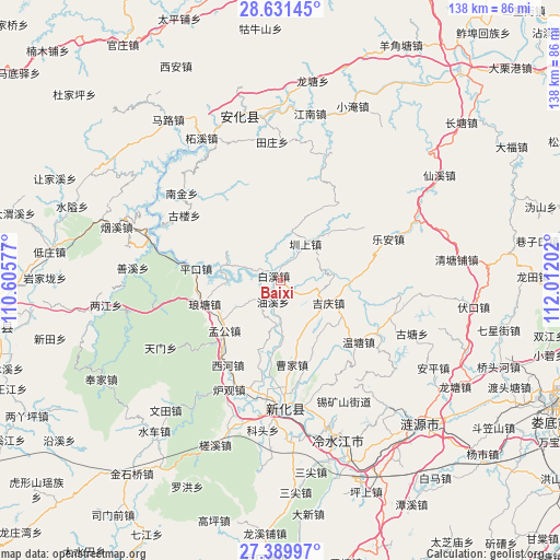
Baixi GPS coordinates[2]
28° 0' 45" North, 111° 18' 32.004" East
| Map corner | latitude | longitude |
|---|---|---|
| Upper-left | 28.63145°, | 110.60577° |
| Center: | 28.0125°, | 111.30889° |
| Lower-right: | 27.38997°, | 112.01202° |
| Map W x H: | 138×138 km | = 85.7×85.7mi |
| max Lat: | 53.31946° ⇑74% North |
| Baixi: | 28.0125° |
| min Lat: | ⇓26% South 18.22056° |
| min Long | Baixi | max Long |
| 75.07348° | 111.30889° | 134.28917° |
| W 34.1%⇐ | ⇒65.9% E |
Elevation
Elevation of Baixi is 193 m = 633 ft, and this is 291.8 m = 957 ft below average elevation for this country.
| Max E: |
5622 m = 18445 ft | 46.5% |
| Avg. | 484.8 m = 1591 ft | |
| Baixi | 193 m = 633 ft | |
Min E: |
-3 m = -10 ft | 53.5% |
See also: China elevation on elevation.city.
Geographical zone
Baixi is located in North temperate zone (between Tropic of Cancer and the Arctic Circle). Distance of this Northern Tropic circle is 508.8 km =316.2 mi to South.| Distance of | km | miles | from Baixi |
|---|---|---|---|
| North Pole | 6892.4 | 4282.7 | to North |
| Arctic Circle | 4286.5 | 2663.5 | to North |
| Tropic Cancer | 508.8 | 316.2 | to South |
| Equator | 3114.7 | 1935.4 | to South |


Nearby cities:
15 places around Baixi: (largest is in red/bold)
• Dongping
42.1 km =26.2 mi,  346°
346°
• Gangdong
47.8 km =29.7 mi,  257°
257°
• Gulou
26.7 km =16.6 mi,  309°
309°
• Langtang
15.8 km =9.8 mi,  267°
267°
• Lengshuijiang
38 km =23.6 mi,  161°
161°
• Le’an
28.8 km =17.9 mi,  72°
72°
• Liangjiang
43.9 km =27.3 mi, 261°
• Longtang
48.7 km =30.3 mi,  10°
10°
• Qingtangpu
44.8 km =27.8 mi,  84°
84°
• Shangmei
30 km =18.6 mi,  182°
182°
• Shanxi
34.9 km =21.7 mi, 273°
• Shuiche
47.3 km =29.4 mi,  220°
220°
• Shuitianzhuang
48.9 km =30.4 mi,  275°
275°
• Xianxi
46.6 km =29 mi,  56°
56°
• Zhenshang
12.2 km =7.6 mi,  36°
36°
Sources, notices
• [Note1] Compared only with cities in China existing in our database
• [Src1] Map data: © OpenStreetMap contributors (CC-BY-SA)
• [Src2] Other city data from geonames.org with taken over terms of usage.
• [Src3] Geographical zone / Annual Mean Temperature by Robert A. Rohde @ Wikipedia
