Chengwu geodata
Chengwu (Shandong) is a seat of a third-order administrative division; located in China in Asia/Shanghai (GMT+8) time zone. In our database, there are 1268 cities with bigger population. Compared to other cities in China, 74.8% of cities are located further ↓South; 59.4% of cities are located further ←West and 71.3% of cities have higher elevation than Chengwu. Note1


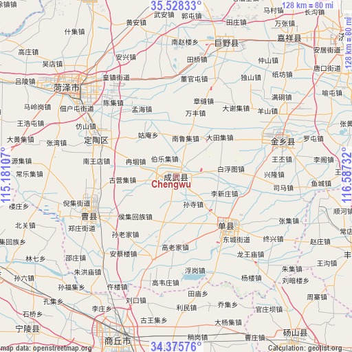
Chengwu GPS coordinates[2]
34° 57' 14.652" North, 115° 53' 3.084" East
| Map corner | latitude | longitude |
|---|---|---|
| Upper-left | 35.52833°, | 115.18107° |
| Center: | 34.95407°, | 115.88419° |
| Lower-right: | 34.37576°, | 116.58732° |
| Map W x H: | 128.2×128.2 km | = 79.7×79.7mi |
| max Lat: | 53.31946° ⇑25.2% North |
| Chengwu: | 34.95407° |
| min Lat: | ⇓74.8% South 18.22056° |
| min Long | Chengwu | max Long |
| 75.07348° | 115.88419° | 134.28917° |
| W 59.4%⇐ | ⇒40.6% E |
Elevation
Elevation of Chengwu is 47 m = 154 ft, and this is 437.8 m = 1436 ft below average elevation for this country.
| Max E: |
5622 m = 18445 ft | 71.3% |
| Avg. | 484.8 m = 1591 ft | |
| Chengwu | 47 m = 154 ft | |
Min E: |
-3 m = -10 ft | 28.7% |
See also: China elevation on elevation.city.
Geographical zone
Chengwu is located in North temperate zone (between Tropic of Cancer and the Arctic Circle). Distance of this Northern Tropic circle is 1280.6 km =795.7 mi to South.| Distance of | km | miles | from Chengwu |
|---|---|---|---|
| North Pole | 6120.5 | 3803.1 | to North |
| Arctic Circle | 3514.6 | 2183.9 | to North |
| Tropic Cancer | 1280.6 | 795.7 | to South |
| Equator | 3886.5 | 2415 | to South |


Nearby cities:
15 places around Chengwu: (largest is in red/bold)
• Chezhan
62.7 km =39 mi,  168°
168°
• Dangcheng
73.8 km =45.9 mi,  142°
142°
• Dingtao
31.9 km =19.8 mi,  294°
294°
• Fengxian
69.9 km =43.4 mi,  113°
113°
• Heze
49 km =30.4 mi,  310°
310°
• Jiaxiang
64.7 km =40.2 mi,  40°
40°
• Juancheng
76 km =47.2 mi,  332°
332°
• Juye
52.4 km =32.6 mi,  20°
20°
• Minquan Chengguanzhen
75.8 km =47.1 mi,  244°
244°
• Ningling Chengguanzhen
76.4 km =47.5 mi,  222°
222°
• Shancheng
25.2 km =15.7 mi,  134°
134°
• Shangqiu
60 km =37.3 mi,  200°
200°
• Xicheng
52.3 km =32.5 mi, 308°
• Yucheng
53 km =32.9 mi,  93°
93°
• Yuncheng
71.8 km =44.6 mi,  3°
3°
Sources, notices
• [Note1] Compared only with cities in China existing in our database
• [Src1] Map data: © OpenStreetMap contributors (CC-BY-SA)
• [Src2] Other city data from geonames.org with taken over terms of usage.
• [Src3] Geographical zone / Annual Mean Temperature by Robert A. Rohde @ Wikipedia
