Xin’anjiang geodata
Xin’anjiang (Zhejiang) is a seat of a third-order administrative division; located in China in Asia/Shanghai (GMT+8) time zone. In our database, there are 1268 cities with bigger population. Compared to other cities in China, 60% of cities are located further ↑North; 77.3% of cities are located further ←West and 70.8% of cities have higher elevation than Xin’anjiang. Note1


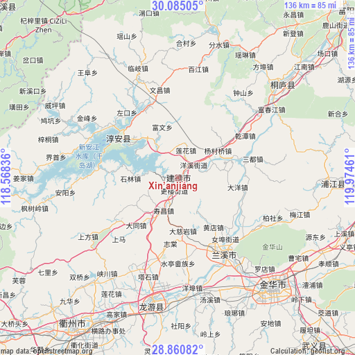
Xin’anjiang GPS coordinates[2]
29° 28' 29.208" North, 119° 16' 17.328" East
| Map corner | latitude | longitude |
|---|---|---|
| Upper-left | 30.08505°, | 118.56836° |
| Center: | 29.47478°, | 119.27148° |
| Lower-right: | 28.86082°, | 119.97461° |
| Map W x H: | 136.1×136.1 km | = 84.6×84.6mi |
| max Lat: | 53.31946° ⇑60% North |
| Xin’anjiang: | 29.47478° |
| min Lat: | ⇓40% South 18.22056° |
| min Long | Xin’anjiang | max Long |
| 75.07348° | 119.27148° | 134.28917° |
| W 77.3%⇐ | ⇒22.7% E |
Elevation
Elevation of Xin’anjiang is 49 m = 161 ft, and this is 435.8 m = 1430 ft below average elevation for this country.
| Max E: |
5622 m = 18445 ft | 70.8% |
| Avg. | 484.8 m = 1591 ft | |
| Xin’anjiang | 49 m = 161 ft | |
Min E: |
-3 m = -10 ft | 29.2% |
See also: China elevation on elevation.city.
Geographical zone
Xin’anjiang is located in North temperate zone (between Tropic of Cancer and the Arctic Circle). Distance of this Northern Tropic circle is 671.4 km =417.2 mi to South.| Distance of | km | miles | from Xin’anjiang |
|---|---|---|---|
| North Pole | 6729.8 | 4181.7 | to North |
| Arctic Circle | 4123.9 | 2562.5 | to North |
| Tropic Cancer | 671.4 | 417.2 | to South |
| Equator | 3277.3 | 2036.4 | to South |


Nearby cities:
15 places around Xin’anjiang: (largest is in red/bold)
• Datong
24.2 km =15 mi,  221°
221°
• Dayang
23.3 km =14.5 mi,  98°
98°
• Houren
25.7 km =16 mi,  153°
153°
• Liyang
27 km =16.8 mi,  271°
271°
• Meicheng
23.3 km =14.5 mi,  71°
71°
• Nübu
29.9 km =18.6 mi,  142°
142°
• Qiantan
30.5 km =19 mi,  58°
58°
• Sandu
29.7 km =18.5 mi,  76°
76°
• Shouchang
13.8 km =8.6 mi,  202°
202°
• Tangcun
21.1 km =13.1 mi,  172°
172°
• Tongjia
14 km =8.7 mi,  241°
241°
• Xiabao
31.8 km =19.8 mi,  41°
41°
• Yongchang
28.5 km =17.7 mi,  163°
163°
• Zhitang
25.4 km =15.8 mi,  186°
186°
• Zhuge
24.9 km =15.5 mi,  175°
175°
Sources, notices
• [Note1] Compared only with cities in China existing in our database
• [Src1] Map data: © OpenStreetMap contributors (CC-BY-SA)
• [Src2] Other city data from geonames.org with taken over terms of usage.
• [Src3] Geographical zone / Annual Mean Temperature by Robert A. Rohde @ Wikipedia
