Daxi geodata
Daxi (Chongqing) is a seat of a fourth-order administrative division; located in China in Asia/Shanghai (GMT+8) time zone. In our database, there are 1268 cities with bigger population. Compared to other cities in China, 54.8% of cities are located further ↓South; 73.1% of cities are located further →East and 62.7% of cities have lower elevation than Daxi. Note1


Daxi GPS coordinates[2]
30° 59' 57.768" North, 109° 38' 16.98" East
| Map corner | latitude | longitude |
|---|---|---|
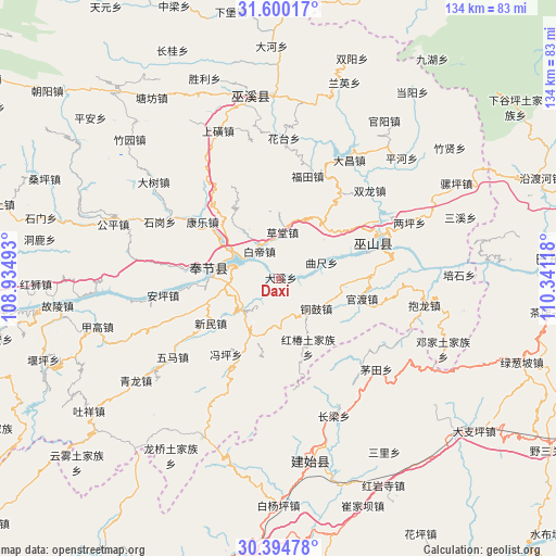
| Upper-left | 31.60017°, | 108.93493° |
| Center: | 30.99938°, | 109.63805° |
| Lower-right: | 30.39478°, | 110.34118° |
| Map W x H: | 134×134 km | = 83.3×83.3mi |
| max Lat: | 53.31946° ⇑45.2% North |
| Daxi: | 30.99938° |
| min Lat: | ⇓54.8% South 18.22056° |
| min Long | Daxi | max Long |
| 75.07348° | 109.63805° | 134.28917° |
| W 26.9%⇐ | ⇒73.1% E |
Elevation
Elevation of Daxi is 292 m = 958 ft, and this is 192.8 m = 633 ft below average elevation for this country.
| Max E: |
5622 m = 18445 ft | 37.3% |
| Avg. | 484.8 m = 1591 ft | |
| Daxi | 292 m = 958 ft | |
Min E: |
-3 m = -10 ft | 62.7% |
See also: China elevation on elevation.city.
Geographical zone
Daxi is located in North temperate zone (between Tropic of Cancer and the Arctic Circle). Distance of this Northern Tropic circle is 840.9 km =522.5 mi to South.| Distance of | km | miles | from Daxi |
|---|---|---|---|
| North Pole | 6560.3 | 4076.4 | to North |
| Arctic Circle | 3954.4 | 2457.1 | to North |
| Tropic Cancer | 840.9 | 522.5 | to South |
| Equator | 3446.8 | 2141.7 | to South |


Nearby cities:
15 places around Daxi: (largest is in red/bold)
• Baidi
7.9 km =4.9 mi,  325°
325°
• Caotang
10.2 km =6.3 mi,  352°
352°
• Chang’an
20.2 km =12.6 mi,  202°
202°
• Fengping
22.3 km =13.9 mi,  214°
214°
• Fenhe
18.9 km =11.7 mi,  324°
324°
• Guandu
20.5 km =12.7 mi,  103°
103°
• Hongchun
17.8 km =11.1 mi,  156°
156°
• Kangle
23.5 km =14.6 mi,  302°
302°
• Miaoyu
14.6 km =9.1 mi,  176°
176°
• Quchi
11.3 km =7 mi,  68°
68°
• Tonggu
11.5 km =7.1 mi,  129°
129°
• Xinmin
19.5 km =12.1 mi,  236°
236°
• Yanwan
24.1 km =15 mi, 334°
• Yongle
12.8 km =8 mi,  275°
275°
• Yong’an
17.3 km =10.7 mi, 277°
Sources, notices
• [Note1] Compared only with cities in China existing in our database
• [Src1] Map data: © OpenStreetMap contributors (CC-BY-SA)
• [Src2] Other city data from geonames.org with taken over terms of usage.
• [Src3] Geographical zone / Annual Mean Temperature by Robert A. Rohde @ Wikipedia
