Tonggu geodata
Tonggu (Chongqing) is a seat of a fourth-order administrative division; located in China in Asia/Shanghai (GMT+8) time zone. In our database, there are 1268 cities with bigger population. Compared to other cities in China, 54.3% of cities are located further ↓South; 72.6% of cities are located further →East and 84.2% of cities have lower elevation than Tonggu. Note1


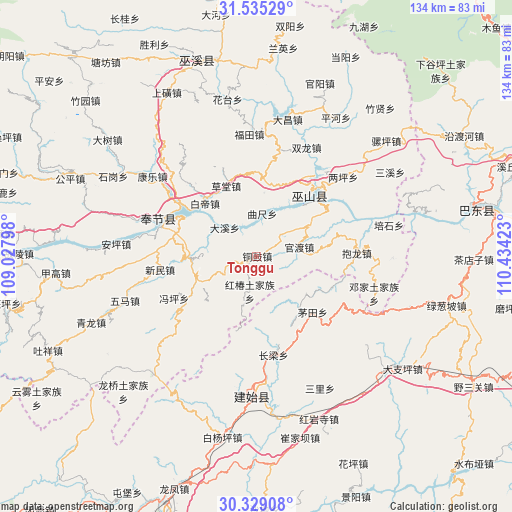
Tonggu GPS coordinates[2]
30° 56' 2.724" North, 109° 43' 51.96" East
| Map corner | latitude | longitude |
|---|---|---|
| Upper-left | 31.53529°, | 109.02798° |
| Center: | 30.93409°, | 109.7311° |
| Lower-right: | 30.32908°, | 110.43423° |
| Map W x H: | 134.1×134.1 km | = 83.3×83.3mi |
| max Lat: | 53.31946° ⇑45.7% North |
| Tonggu: | 30.93409° |
| min Lat: | ⇓54.3% South 18.22056° |
| min Long | Tonggu | max Long |
| 75.07348° | 109.7311° | 134.28917° |
| W 27.4%⇐ | ⇒72.6% E |
Elevation
Elevation of Tonggu is 927 m = 3041 ft, and this is 442.2 m = 1451 ft above average elevation for this country.
| Max E: |
5622 m = 18445 ft | 15.8% |
| Tonggu | 927 m 3041 ft | |
| Avg. | 484.8 m = 1591 ft | |
Min E: |
-3 m = -10 ft | 84.2% |
See also: China elevation on elevation.city.
Geographical zone
Tonggu is located in North temperate zone (between Tropic of Cancer and the Arctic Circle). Distance of this Northern Tropic circle is 833.6 km =518 mi to South.| Distance of | km | miles | from Tonggu |
|---|---|---|---|
| North Pole | 6567.5 | 4080.9 | to North |
| Arctic Circle | 3961.6 | 2461.6 | to North |
| Tropic Cancer | 833.6 | 518 | to South |
| Equator | 3439.5 | 2137.2 | to South |


Nearby cities:
15 places around Tonggu: (largest is in red/bold)
• Baidi
19.2 km =11.9 mi,  315°
315°
• Caotang
20.1 km =12.5 mi,  329°
329°
• Chang’an
20.1 km =12.5 mi,  235°
235°
• Daxi
11.5 km =7.1 mi,  309°
309°
• Fengping
24.2 km =15 mi, 242°
• Guandu
11.3 km =7 mi,  77°
77°
• Hongchun
9.3 km =5.8 mi,  191°
191°
• Jianping
22.2 km =13.8 mi,  56°
56°
• Longjing
22.8 km =14.2 mi,  40°
40°
• Maotian
20.6 km =12.8 mi,  134°
134°
• Miaoyu
10.9 km =6.8 mi,  228°
228°
• Quchi
11.5 km =7.1 mi,  8°
8°
• Wushan
21.3 km =13.2 mi, 40°
• Xinmin
25.4 km =15.8 mi,  262°
262°
• Yongle
23.2 km =14.4 mi,  291°
291°
Sources, notices
• [Note1] Compared only with cities in China existing in our database
• [Src1] Map data: © OpenStreetMap contributors (CC-BY-SA)
• [Src2] Other city data from geonames.org with taken over terms of usage.
• [Src3] Geographical zone / Annual Mean Temperature by Robert A. Rohde @ Wikipedia
