Xishan geodata
Xishan (Jiangxi) is a seat of a fourth-order administrative division; located in China in Asia/Shanghai (GMT+8) time zone. In our database, there are 1268 cities with bigger population. Compared to other cities in China, 69.3% of cities are located further ↑North; 57.7% of cities are located further ←West and 76.2% of cities have higher elevation than Xishan. Note1


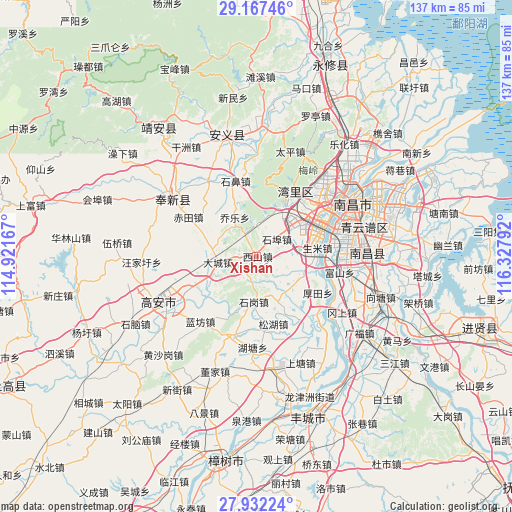
Xishan GPS coordinates[2]
28° 33' 5.976" North, 115° 37' 29.244" East
| Map corner | latitude | longitude |
|---|---|---|
| Upper-left | 29.16746°, | 114.92167° |
| Center: | 28.55166°, | 115.62479° |
| Lower-right: | 27.93224°, | 116.32792° |
| Map W x H: | 137.3×137.3 km | = 85.3×85.3mi |
| max Lat: | 53.31946° ⇑69.3% North |
| Xishan: | 28.55166° |
| min Lat: | ⇓30.7% South 18.22056° |
| min Long | Xishan | max Long |
| 75.07348° | 115.62479° | 134.28917° |
| W 57.7%⇐ | ⇒42.3% E |
Elevation
Elevation of Xishan is 34 m = 112 ft, and this is 450.8 m = 1479 ft below average elevation for this country.
| Max E: |
5622 m = 18445 ft | 76.2% |
| Avg. | 484.8 m = 1591 ft | |
| Xishan | 34 m = 112 ft | |
Min E: |
-3 m = -10 ft | 23.8% |
See also: China elevation on elevation.city.
Geographical zone
Xishan is located in North temperate zone (between Tropic of Cancer and the Arctic Circle). Distance of this Northern Tropic circle is 568.7 km =353.4 mi to South.| Distance of | km | miles | from Xishan |
|---|---|---|---|
| North Pole | 6832.4 | 4245.5 | to North |
| Arctic Circle | 4226.5 | 2626.2 | to North |
| Tropic Cancer | 568.7 | 353.4 | to South |
| Equator | 3174.6 | 1972.6 | to South |


Nearby cities:
15 places around Xishan: (largest is in red/bold)
• Dacheng
10.5 km =6.5 mi,  261°
261°
• Dongxin
20.3 km =12.6 mi,  78°
78°
• Fushan
22.7 km =14.1 mi,  100°
100°
• Houtian
18.8 km =11.7 mi,  120°
120°
• Huangcheng
22.2 km =13.8 mi,  196°
196°
• Lanfangzhen
23.2 km =14.4 mi,  221°
221°
• Liuhu
13.2 km =8.2 mi,  133°
133°
• Qiaole
11.9 km =7.4 mi,  329°
329°
• Shengmi
16.5 km =10.3 mi, 81°
• Shibi
20.6 km =12.8 mi,  344°
344°
• Shigang
12.1 km =7.5 mi,  179°
179°
• Songhu
19.4 km =12.1 mi,  172°
172°
• Wangcheng
20.4 km =12.7 mi,  48°
48°
• Xiangfu
20.8 km =12.9 mi,  245°
245°
• Zhaoxian
20.3 km =12.6 mi,  32°
32°
Sources, notices
• [Note1] Compared only with cities in China existing in our database
• [Src1] Map data: © OpenStreetMap contributors (CC-BY-SA)
• [Src2] Other city data from geonames.org with taken over terms of usage.
• [Src3] Geographical zone / Annual Mean Temperature by Robert A. Rohde @ Wikipedia
