Yinglong geodata
Yinglong (Chongqing) is a seat of a fourth-order administrative division; located in China in Asia/Shanghai (GMT+8) time zone. In our database, there are 1268 cities with bigger population. Compared to other cities in China, 59.5% of cities are located further ↑North; 84.5% of cities are located further →East and 57% of cities have lower elevation than Yinglong. Note1


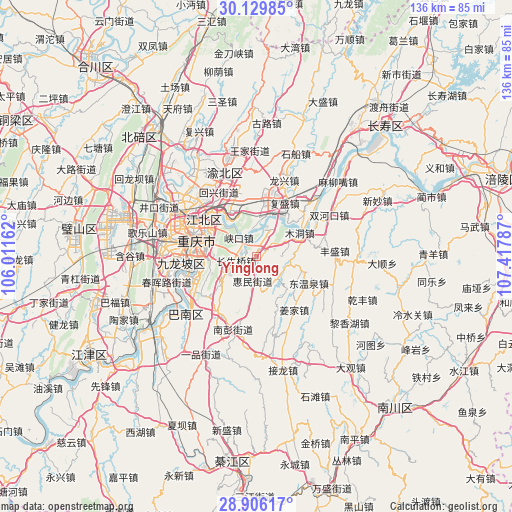
Yinglong GPS coordinates[2]
29° 31' 11.496" North, 106° 42' 53.064" East
| Map corner | latitude | longitude |
|---|---|---|
| Upper-left | 30.12985°, | 106.01162° |
| Center: | 29.51986°, | 106.71474° |
| Lower-right: | 28.90617°, | 107.41787° |
| Map W x H: | 136.1×136.1 km | = 84.6×84.6mi |
| max Lat: | 53.31946° ⇑59.5% North |
| Yinglong: | 29.51986° |
| min Lat: | ⇓40.5% South 18.22056° |
| min Long | Yinglong | max Long |
| 75.07348° | 106.71474° | 134.28917° |
| W 15.5%⇐ | ⇒84.5% E |
Elevation
Elevation of Yinglong is 226 m = 741 ft, and this is 258.8 m = 849 ft below average elevation for this country.
| Max E: |
5622 m = 18445 ft | 43% |
| Avg. | 484.8 m = 1591 ft | |
| Yinglong | 226 m = 741 ft | |
Min E: |
-3 m = -10 ft | 57% |
See also: China elevation on elevation.city.
Geographical zone
Yinglong is located in North temperate zone (between Tropic of Cancer and the Arctic Circle). Distance of this Northern Tropic circle is 676.4 km =420.3 mi to South.| Distance of | km | miles | from Yinglong |
|---|---|---|---|
| North Pole | 6724.8 | 4178.6 | to North |
| Arctic Circle | 4118.9 | 2559.4 | to North |
| Tropic Cancer | 676.4 | 420.3 | to South |
| Equator | 3282.3 | 2039.5 | to South |


Nearby cities:
15 places around Yinglong: (largest is in red/bold)
• Changshengqiao
5.4 km =3.4 mi,  256°
256°
• Chongqing
16.4 km =10.2 mi,  286°
286°
• Cuntan
16.7 km =10.4 mi,  303°
303°
• Fengsheng
21.1 km =13.1 mi,  86°
86°
• Fusheng
16 km =9.9 mi,  27°
27°
• Guangyang
8 km =5 mi, 27°
• Huimin
6.5 km =4 mi,  188°
188°
• Huixing
20.7 km =12.9 mi,  332°
332°
• Jiguanshi
13.5 km =8.4 mi,  308°
308°
• Mudong
13.6 km =8.5 mi,  63°
63°
• Nanping
12.5 km =7.8 mi,  280°
280°
• Wubao
16.8 km =10.4 mi,  41°
41°
• Yangjiaping
20.7 km =12.9 mi,  265°
265°
• Yufengshan
16.7 km =10.4 mi,  343°
343°
• Yuzui
12.1 km =7.5 mi,  22°
22°
Sources, notices
• [Note1] Compared only with cities in China existing in our database
• [Src1] Map data: © OpenStreetMap contributors (CC-BY-SA)
• [Src2] Other city data from geonames.org with taken over terms of usage.
• [Src3] Geographical zone / Annual Mean Temperature by Robert A. Rohde @ Wikipedia
