Chengyang geodata
Chengyang (Ningxia Hui Autonomous Region) is a seat of a fourth-order administrative division; located in China in Asia/Shanghai (GMT+8) time zone. In our database, there are 1268 cities with bigger population. Compared to other cities in China, 76.8% of cities are located further ↓South; 84.3% of cities are located further →East and 90.5% of cities have lower elevation than Chengyang. Note1


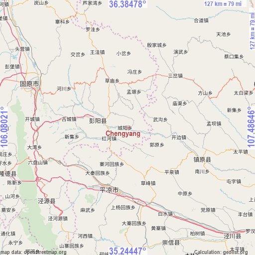
Chengyang GPS coordinates[2]
35° 49' 0.012" North, 106° 46' 59.988" East
| Map corner | latitude | longitude |
|---|---|---|
| Upper-left | 36.38478°, | 106.08021° |
| Center: | 35.81667°, | 106.78333° |
| Lower-right: | 35.24447°, | 107.48646° |
| Map W x H: | 126.8×126.8 km | = 78.8×78.8mi |
| max Lat: | 53.31946° ⇑23.2% North |
| Chengyang: | 35.81667° |
| min Lat: | ⇓76.8% South 18.22056° |
| min Long | Chengyang | max Long |
| 75.07348° | 106.78333° | 134.28917° |
| W 15.7%⇐ | ⇒84.3% E |
Elevation
Elevation of Chengyang is 1401 m = 4596 ft, and this is 916.2 m = 3006 ft above average elevation for this country.
| Max E: |
5622 m = 18445 ft | 9.5% |
| Chengyang | 1401 m 4596 ft | |
| Avg. | 484.8 m = 1591 ft | |
Min E: |
-3 m = -10 ft | 90.5% |
See also: China elevation on elevation.city.
Geographical zone
Chengyang is located in North temperate zone (between Tropic of Cancer and the Arctic Circle). Distance of this Northern Tropic circle is 1376.5 km =855.3 mi to South.| Distance of | km | miles | from Chengyang |
|---|---|---|---|
| North Pole | 6024.6 | 3743.5 | to North |
| Arctic Circle | 3418.7 | 2124.3 | to North |
| Tropic Cancer | 1376.5 | 855.3 | to South |
| Equator | 3982.4 | 2474.5 | to South |


Nearby cities:
15 places around Chengyang: (largest is in red/bold)
• Baiyang
13.6 km =8.5 mi,  286°
286°
• Beiwa
39.1 km =24.3 mi,  336°
336°
• Caomiao
24.8 km =15.4 mi, 342°
• Gonghe
46.9 km =29.1 mi,  306°
306°
• Gucheng
29.7 km =18.5 mi,  278°
278°
• Honghe
9.3 km =5.8 mi,  233°
233°
• Jiaocha
44.2 km =27.5 mi,  326°
326°
• Pingliang
32.1 km =19.9 mi,  195°
195°
• Sancha
35.2 km =21.9 mi,  42°
42°
• Shicha
29.9 km =18.6 mi,  315°
315°
• Xiaocha
37.3 km =23.2 mi,  356°
356°
• Xiawangwa
34.8 km =21.6 mi, 337°
• Yanwu
46 km =28.6 mi,  34°
34°
• Yinjiacheng
43.7 km =27.2 mi,  18°
18°
• Zhenyuan Chengguanzhen
40.4 km =25.1 mi,  112°
112°
Sources, notices
• [Note1] Compared only with cities in China existing in our database
• [Src1] Map data: © OpenStreetMap contributors (CC-BY-SA)
• [Src2] Other city data from geonames.org with taken over terms of usage.
• [Src3] Geographical zone / Annual Mean Temperature by Robert A. Rohde @ Wikipedia
