Pingliang geodata
Pingliang (Gansu) is a seat of a second-order administrative division; located in China in Asia/Shanghai (GMT+8) time zone. With population of 108,156 people, there are 406 cities with bigger population in this country. Compared to other cities in China, 76.1% of cities are located further ↓South; 84.6% of cities are located further →East and 89.9% of cities have lower elevation than Pingliang. Note1


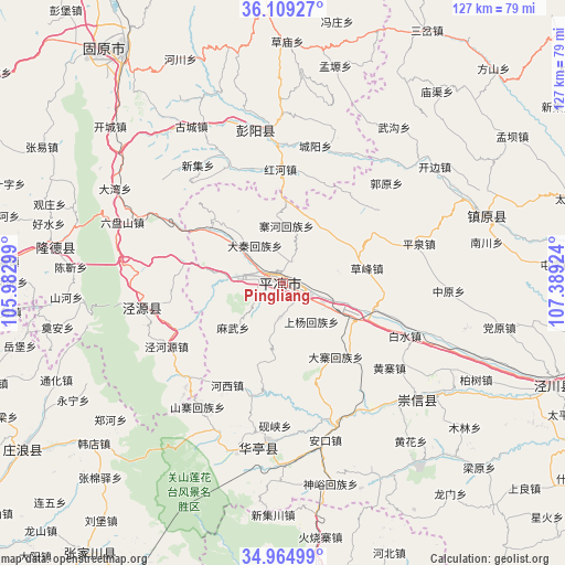
Pingliang GPS coordinates[2]
35° 32' 21.012" North, 106° 41' 9.996" East
| Map corner | latitude | longitude |
|---|---|---|
| Upper-left | 36.10927°, | 105.98299° |
| Center: | 35.53917°, | 106.68611° |
| Lower-right: | 34.96499°, | 107.38924° |
| Map W x H: | 127.2×127.2 km | = 79×79mi |
| max Lat: | 53.31946° ⇑23.9% North |
| Pingliang: | 35.53917° |
| min Lat: | ⇓76.1% South 18.22056° |
| min Long | Pingliang | max Long |
| 75.07348° | 106.68611° | 134.28917° |
| W 15.4%⇐ | ⇒84.6% E |
Elevation
Elevation of Pingliang is 1354 m = 4442 ft, and this is 869.2 m = 2852 ft above average elevation for this country.
| Max E: |
5622 m = 18445 ft | 10.1% |
| Pingliang | 1354 m 4442 ft | |
| Avg. | 484.8 m = 1591 ft | |
Min E: |
-3 m = -10 ft | 89.9% |
See also: Pingliang elevation on elevation.city.
Geographical zone
Pingliang is located in North temperate zone (between Tropic of Cancer and the Arctic Circle). Distance of this Northern Tropic circle is 1345.7 km =836.2 mi to South.| Distance of | km | miles | from Pingliang |
|---|---|---|---|
| North Pole | 6055.5 | 3762.7 | to North |
| Arctic Circle | 3449.6 | 2143.5 | to North |
| Tropic Cancer | 1345.7 | 836.2 | to South |
| Equator | 3951.6 | 2455.4 | to South |


Nearby cities:
15 places around Pingliang: (largest is in red/bold)
• Ankou
36.6 km =22.7 mi,  164°
164°
• Baiyang
34.9 km =21.7 mi,  353°
353°
• Chengyang
32.1 km =19.9 mi,  15°
15°
• Chenjin
48.6 km =30.2 mi,  273°
273°
• Donghua
36.1 km =22.4 mi,  184°
184°
• Gucheng
40.9 km =25.4 mi,  329°
329°
• Haoshui
54.4 km =33.8 mi,  283°
283°
• Honghe
25.3 km =15.7 mi,  2°
2°
• Jinping
39.9 km =24.8 mi,  128°
128°
• Longde Chengguanzhen
52.1 km =32.4 mi, 278°
• Shanhe
48.6 km =30.2 mi, 267°
• Shicha
53.6 km =33.3 mi, 346°
• Xiangshui
32.9 km =20.4 mi,  257°
257°
• Xingsheng
33.4 km =20.8 mi,  252°
252°
• Zhenyuan Chengguanzhen
48.6 km =30.2 mi,  71°
71°
Sources, notices
• [Note1] Compared only with cities in China existing in our database
• [Src1] Map data: © OpenStreetMap contributors (CC-BY-SA)
• [Src2] Other city data from geonames.org with taken over terms of usage.
• [Src3] Geographical zone / Annual Mean Temperature by Robert A. Rohde @ Wikipedia
