Pingshan geodata
Pingshan (Guangdong) is a seat of a fourth-order administrative division; located in China in Asia/Urumqi (GMT+6) time zone. In our database, there are 1268 cities with bigger population. Compared to other cities in China, 97.1% of cities are located further ↑North; 66.7% of cities are located further →East and 61.1% of cities have higher elevation than Pingshan. Note1


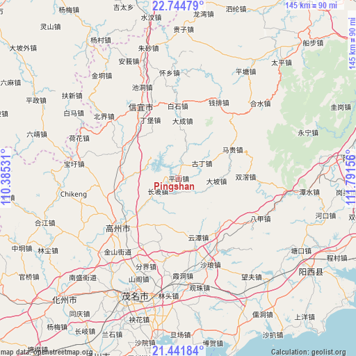
Pingshan GPS coordinates[2]
22° 5' 41.352" North, 111° 5' 18.348" East
| Map corner | latitude | longitude |
|---|---|---|
| Upper-left | 22.74479°, | 110.38531° |
| Center: | 22.09482°, | 111.08843° |
| Lower-right: | 21.44184°, | 111.79156° |
| Map W x H: | 144.9×144.9 km | = 90×90mi |
| max Lat: | 53.31946° ⇑97.1% North |
| Pingshan: | 22.09482° |
| min Lat: | ⇓2.9% South 18.22056° |
| min Long | Pingshan | max Long |
| 75.07348° | 111.08843° | 134.28917° |
| W 33.3%⇐ | ⇒66.7% E |
Elevation
Elevation of Pingshan is 92 m = 302 ft, and this is 392.8 m = 1289 ft below average elevation for this country.
| Max E: |
5622 m = 18445 ft | 61.1% |
| Avg. | 484.8 m = 1591 ft | |
| Pingshan | 92 m = 302 ft | |
Min E: |
-3 m = -10 ft | 38.9% |
See also: China elevation on elevation.city.
Geographical zone
Pingshan is located in North Torrid zone (between Equator and Tropic of Cancer). Distance of this Northern Tropic circle is 149.2 km =92.7 mi to North.| Distance of | km | miles | from Pingshan |
|---|---|---|---|
| North Pole | 7550.3 | 4691.5 | to North |
| Arctic Circle | 4944.5 | 3072.4 | to North |
| Tropic Cancer | 149.2 | 92.7 | to North |
| Equator | 2456.7 | 1526.5 | to South |


Nearby cities:
15 places around Pingshan: (largest is in red/bold)
• Caojiang
19.2 km =11.9 mi,  230°
230°
• Changpo
8.1 km =5 mi,  245°
245°
• Dacheng
22.6 km =14 mi,  4°
4°
• Dajing
22.4 km =13.9 mi,  266°
266°
• Dapo
16.2 km =10.1 mi,  95°
95°
• Dingbao
25.8 km =16 mi,  332°
332°
• Dong’an
14.7 km =9.1 mi,  285°
285°
• Guding
12.8 km =8 mi,  60°
60°
• Shenzhen
10.2 km =6.3 mi,  17°
17°
• Shuikou
24.9 km =15.5 mi,  313°
313°
• Tantou
25.8 km =16 mi, 292°
• Xieji
22.6 km =14 mi,  208°
208°
• Xindong
20.9 km =13 mi,  187°
187°
• Yuntan
24.7 km =15.3 mi,  161°
161°
• Zhenlong
25.6 km =15.9 mi,  300°
300°
Sources, notices
• [Note1] Compared only with cities in China existing in our database
• [Src1] Map data: © OpenStreetMap contributors (CC-BY-SA)
• [Src2] Other city data from geonames.org with taken over terms of usage.
• [Src3] Geographical zone / Annual Mean Temperature by Robert A. Rohde @ Wikipedia
