Qiandeng geodata
Qiandeng (Jiangsu) is a seat of a fourth-order administrative division; located in China in Asia/Shanghai (GMT+8) time zone. In our database, there are 1268 cities with bigger population. Compared to other cities in China, 56.7% of cities are located further ↓South; 87.8% of cities are located further ←West and 95.9% of cities have higher elevation than Qiandeng. Note1


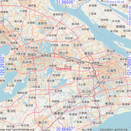
Qiandeng GPS coordinates[2]
31° 16' 1.128" North, 120° 59' 48.984" East
| Map corner | latitude | longitude |
|---|---|---|
| Upper-left | 31.86606°, | 120.29382° |
| Center: | 31.26698°, | 120.99694° |
| Lower-right: | 30.66407°, | 121.70007° |
| Map W x H: | 133.6×133.6 km | = 83×83mi |
| max Lat: | 53.31946° ⇑43.3% North |
| Qiandeng: | 31.26698° |
| min Lat: | ⇓56.7% South 18.22056° |
| min Long | Qiandeng | max Long |
| 75.07348° | 120.99694° | 134.28917° |
| W 87.8%⇐ | ⇒12.2% E |
Elevation
Elevation of Qiandeng is 6 m = 20 ft, and this is 478.8 m = 1571 ft below average elevation for this country.
| Max E: |
5622 m = 18445 ft | 95.9% |
| Avg. | 484.8 m = 1591 ft | |
| Qiandeng | 6 m = 20 ft | |
Min E: |
-3 m = -10 ft | 4.1% |
See also: China elevation on elevation.city.
Geographical zone
Qiandeng is located in North temperate zone (between Tropic of Cancer and the Arctic Circle). Distance of this Northern Tropic circle is 870.6 km =541 mi to South.| Distance of | km | miles | from Qiandeng |
|---|---|---|---|
| North Pole | 6530.5 | 4057.9 | to North |
| Arctic Circle | 3924.6 | 2438.6 | to North |
| Tropic Cancer | 870.6 | 541 | to South |
| Equator | 3476.6 | 2160.3 | to South |


Nearby cities:
15 places around Qiandeng: (largest is in red/bold)
• Anting
15.7 km =9.8 mi,  76°
76°
• Baihe
13.3 km =8.3 mi,  95°
95°
• Chonggu
17.9 km =11.1 mi,  113°
113°
• Dianshanhu
9.6 km =6 mi,  163°
163°
• Huaqiao
9.2 km =5.7 mi,  65°
65°
• Jinxi
13.9 km =8.6 mi,  225°
225°
• Kunshan
13 km =8.1 mi,  341°
341°
• Lujia
7 km =4.3 mi,  39°
39°
• Luzhi
12.3 km =7.6 mi,  274°
274°
• Shengpu
17.7 km =11 mi,  284°
284°
• Xianghuaqiao
15.4 km =9.6 mi,  132°
132°
• Xiayang
17.3 km =10.7 mi,  139°
139°
• Yingpu
16.2 km =10.1 mi, 140°
• Zhangpu
5.2 km =3.2 mi,  295°
295°
• Zhujiajiao
18.6 km =11.6 mi, 162°
Sources, notices
• [Note1] Compared only with cities in China existing in our database
• [Src1] Map data: © OpenStreetMap contributors (CC-BY-SA)
• [Src2] Other city data from geonames.org with taken over terms of usage.
• [Src3] Geographical zone / Annual Mean Temperature by Robert A. Rohde @ Wikipedia
