Nanhe geodata
Nanhe (Hubei) is a seat of a fourth-order administrative division; located in China in Asia/Shanghai (GMT+8) time zone. In our database, there are 1268 cities with bigger population. Compared to other cities in China, 62.3% of cities are located further ↓South; 65% of cities are located further →East and 52.7% of cities have lower elevation than Nanhe. Note1


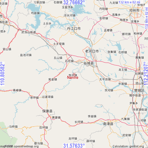
Nanhe GPS coordinates[2]
32° 10' 24.312" North, 111° 30' 32.184" East
| Map corner | latitude | longitude |
|---|---|---|
| Upper-left | 32.76662°, | 110.80582° |
| Center: | 32.17342°, | 111.50894° |
| Lower-right: | 31.57633°, | 112.21207° |
| Map W x H: | 132.3×132.3 km | = 82.2×82.2mi |
| max Lat: | 53.31946° ⇑37.7% North |
| Nanhe: | 32.17342° |
| min Lat: | ⇓62.3% South 18.22056° |
| min Long | Nanhe | max Long |
| 75.07348° | 111.50894° | 134.28917° |
| W 35%⇐ | ⇒65% E |
Elevation
Elevation of Nanhe is 186 m = 610 ft, and this is 298.8 m = 980 ft below average elevation for this country.
| Max E: |
5622 m = 18445 ft | 47.3% |
| Avg. | 484.8 m = 1591 ft | |
| Nanhe | 186 m = 610 ft | |
Min E: |
-3 m = -10 ft | 52.7% |
See also: China elevation on elevation.city.
Geographical zone
Nanhe is located in North temperate zone (between Tropic of Cancer and the Arctic Circle). Distance of this Northern Tropic circle is 971.4 km =603.6 mi to South.| Distance of | km | miles | from Nanhe |
|---|---|---|---|
| North Pole | 6429.7 | 3995.2 | to North |
| Arctic Circle | 3823.8 | 2376 | to North |
| Tropic Cancer | 971.4 | 603.6 | to South |
| Equator | 3577.3 | 2222.8 | to South |


Nearby cities:
15 places around Nanhe: (largest is in red/bold)
• Cihe
33.9 km =21.1 mi,  114°
114°
• Gucheng Chengguanzhen
15.7 km =9.8 mi,  48°
48°
• Guoduwan
31 km =19.3 mi,  229°
229°
• Hongshanzui
34.3 km =21.3 mi,  24°
24°
• Langhe
36.4 km =22.6 mi,  320°
320°
• Laohekou
27.9 km =17.3 mi,  32°
32°
• Lengji
23 km =14.3 mi, 20°
• Miaotan
22.8 km =14.2 mi,  99°
99°
• Sanguandian
38 km =23.6 mi,  356°
356°
• Shihua
12.7 km =7.9 mi,  336°
336°
• Taipingdian
28 km =17.4 mi, 98°
• Tuguanya
30.7 km =19.1 mi,  333°
333°
• Wushan
20.7 km =12.9 mi, 316°
• Xianrendu
21.4 km =13.3 mi,  64°
64°
• Zijin
19.6 km =12.2 mi,  257°
257°
Sources, notices
• [Note1] Compared only with cities in China existing in our database
• [Src1] Map data: © OpenStreetMap contributors (CC-BY-SA)
• [Src2] Other city data from geonames.org with taken over terms of usage.
• [Src3] Geographical zone / Annual Mean Temperature by Robert A. Rohde @ Wikipedia
