Tuguanya geodata
Tuguanya (Hubei) is a seat of a fourth-order administrative division; located in China in Asia/Shanghai (GMT+8) time zone. In our database, there are 1268 cities with bigger population. Compared to other cities in China, 63.6% of cities are located further ↓South; 65.6% of cities are located further →East and 67.9% of cities have lower elevation than Tuguanya. Note1


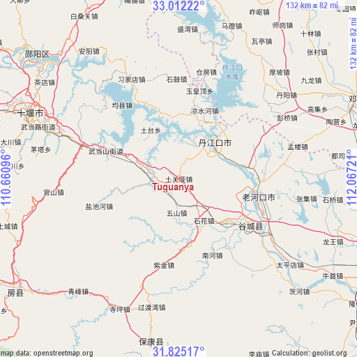
Tuguanya GPS coordinates[2]
32° 25' 14.34" North, 111° 21' 50.688" East
| Map corner | latitude | longitude |
|---|---|---|
| Upper-left | 33.01222°, | 110.66096° |
| Center: | 32.42065°, | 111.36408° |
| Lower-right: | 31.82517°, | 112.06721° |
| Map W x H: | 132×132 km | = 82×82mi |
| max Lat: | 53.31946° ⇑36.4% North |
| Tuguanya: | 32.42065° |
| min Lat: | ⇓63.6% South 18.22056° |
| min Long | Tuguanya | max Long |
| 75.07348° | 111.36408° | 134.28917° |
| W 34.4%⇐ | ⇒65.6% E |
Elevation
Elevation of Tuguanya is 375 m = 1230 ft, and this is 109.8 m = 360 ft below average elevation for this country.
| Max E: |
5622 m = 18445 ft | 32.1% |
| Avg. | 484.8 m = 1591 ft | |
| Tuguanya | 375 m = 1230 ft | |
Min E: |
-3 m = -10 ft | 67.9% |
See also: China elevation on elevation.city.
Geographical zone
Tuguanya is located in North temperate zone (between Tropic of Cancer and the Arctic Circle). Distance of this Northern Tropic circle is 998.9 km =620.7 mi to South.| Distance of | km | miles | from Tuguanya |
|---|---|---|---|
| North Pole | 6402.2 | 3978.1 | to North |
| Arctic Circle | 3796.3 | 2358.9 | to North |
| Tropic Cancer | 998.9 | 620.7 | to South |
| Equator | 3604.8 | 2239.9 | to South |


Nearby cities:
15 places around Tuguanya: (largest is in red/bold)
• Danjiangkou
19.2 km =11.9 mi,  44°
44°
• Danzhaolu
21.3 km =13.2 mi,  46°
46°
• Gucheng Chengguanzhen
30.7 km =19.1 mi,  124°
124°
• Hongshanzui
28 km =17.4 mi,  82°
82°
• Langhe
9.7 km =6 mi,  272°
272°
• Laohekou
28.8 km =17.9 mi,  97°
97°
• Lengji
22.3 km =13.9 mi,  105°
105°
• Liangshuihe
26.9 km =16.7 mi,  20°
20°
• Nanhe
30.7 km =19.1 mi,  153°
153°
• Sanguandian
15.4 km =9.6 mi, 47°
• Shihua
18 km =11.2 mi, 151°
• Tutai
21 km =13 mi,  332°
332°
• Wudangshan
28.8 km =17.9 mi,  291°
291°
• Wushan
12.6 km =7.8 mi,  183°
183°
• Yanchihe
31.1 km =19.3 mi,  250°
250°
Sources, notices
• [Note1] Compared only with cities in China existing in our database
• [Src1] Map data: © OpenStreetMap contributors (CC-BY-SA)
• [Src2] Other city data from geonames.org with taken over terms of usage.
• [Src3] Geographical zone / Annual Mean Temperature by Robert A. Rohde @ Wikipedia
