Wushan geodata
Wushan (Hubei) is a seat of a fourth-order administrative division; located in China in Asia/Shanghai (GMT+8) time zone. In our database, there are 1268 cities with bigger population. Compared to other cities in China, 63% of cities are located further ↓South; 65.6% of cities are located further →East and 50.4% of cities have higher elevation than Wushan. Note1


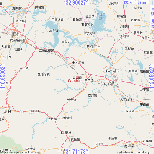
Wushan GPS coordinates[2]
32° 18' 28.62" North, 111° 21' 22.104" East
| Map corner | latitude | longitude |
|---|---|---|
| Upper-left | 32.90027°, | 110.65302° |
| Center: | 32.30795°, | 111.35614° |
| Lower-right: | 31.71173°, | 112.05927° |
| Map W x H: | 132.2×132.2 km | = 82.1×82.1mi |
| max Lat: | 53.31946° ⇑37% North |
| Wushan: | 32.30795° |
| min Lat: | ⇓63% South 18.22056° |
| min Long | Wushan | max Long |
| 75.07348° | 111.35614° | 134.28917° |
| W 34.4%⇐ | ⇒65.6% E |
Elevation
Elevation of Wushan is 161 m = 528 ft, and this is 323.8 m = 1062 ft below average elevation for this country.
| Max E: |
5622 m = 18445 ft | 50.4% |
| Avg. | 484.8 m = 1591 ft | |
| Wushan | 161 m = 528 ft | |
Min E: |
-3 m = -10 ft | 49.6% |
See also: China elevation on elevation.city.
Geographical zone
Wushan is located in North temperate zone (between Tropic of Cancer and the Arctic Circle). Distance of this Northern Tropic circle is 986.4 km =612.9 mi to South.| Distance of | km | miles | from Wushan |
|---|---|---|---|
| North Pole | 6414.8 | 3986 | to North |
| Arctic Circle | 3808.9 | 2366.7 | to North |
| Tropic Cancer | 986.4 | 612.9 | to South |
| Equator | 3592.3 | 2232.2 | to South |


Nearby cities:
15 places around Wushan: (largest is in red/bold)
• Danjiangkou
29.8 km =18.5 mi,  28°
28°
• Danzhaolu
31.7 km =19.7 mi, 30°
• Gucheng Chengguanzhen
26.6 km =16.5 mi,  100°
100°
• Hongshanzui
32.9 km =20.4 mi,  60°
60°
• Langhe
15.8 km =9.8 mi,  325°
325°
• Laohekou
30.5 km =19 mi,  73°
73°
• Lengji
23.2 km =14.4 mi, 73°
• Nanhe
20.7 km =12.9 mi,  136°
136°
• Sanguandian
25.9 km =16.1 mi, 27°
• Shihua
10 km =6.2 mi,  109°
109°
• Tuguanya
12.6 km =7.8 mi,  3°
3°
• Tutai
32.4 km =20.1 mi,  343°
343°
• Xianrendu
34.1 km =21.2 mi, 99°
• Yanchihe
28.8 km =17.9 mi,  274°
274°
• Zijin
19.8 km =12.3 mi,  193°
193°
Sources, notices
• [Note1] Compared only with cities in China existing in our database
• [Src1] Map data: © OpenStreetMap contributors (CC-BY-SA)
• [Src2] Other city data from geonames.org with taken over terms of usage.
• [Src3] Geographical zone / Annual Mean Temperature by Robert A. Rohde @ Wikipedia
