Tongjia geodata
Tongjia (Zhejiang) is a seat of a fourth-order administrative division; located in China in Asia/Shanghai (GMT+8) time zone. In our database, there are 1268 cities with bigger population. Compared to other cities in China, 60.7% of cities are located further ↑North; 76.8% of cities are located further ←West and 52.7% of cities have higher elevation than Tongjia. Note1


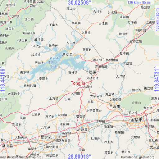
Tongjia GPS coordinates[2]
29° 24' 52.02" North, 119° 8' 39.048" East
| Map corner | latitude | longitude |
|---|---|---|
| Upper-left | 30.02508°, | 118.44106° |
| Center: | 29.41445°, | 119.14418° |
| Lower-right: | 28.80013°, | 119.84731° |
| Map W x H: | 136.2×136.2 km | = 84.6×84.6mi |
| max Lat: | 53.31946° ⇑60.7% North |
| Tongjia: | 29.41445° |
| min Lat: | ⇓39.3% South 18.22056° |
| min Long | Tongjia | max Long |
| 75.07348° | 119.14418° | 134.28917° |
| W 76.8%⇐ | ⇒23.2% E |
Elevation
Elevation of Tongjia is 145 m = 476 ft, and this is 339.8 m = 1115 ft below average elevation for this country.
| Max E: |
5622 m = 18445 ft | 52.7% |
| Avg. | 484.8 m = 1591 ft | |
| Tongjia | 145 m = 476 ft | |
Min E: |
-3 m = -10 ft | 47.3% |
See also: China elevation on elevation.city.
Geographical zone
Tongjia is located in North temperate zone (between Tropic of Cancer and the Arctic Circle). Distance of this Northern Tropic circle is 664.7 km =413 mi to South.| Distance of | km | miles | from Tongjia |
|---|---|---|---|
| North Pole | 6736.5 | 4185.9 | to North |
| Arctic Circle | 4130.6 | 2566.6 | to North |
| Tropic Cancer | 664.7 | 413 | to South |
| Equator | 3270.6 | 2032.3 | to South |


Nearby cities:
15 places around Tongjia: (largest is in red/bold)
• Datong
12.1 km =7.5 mi,  197°
197°
• Hengshan
26.8 km =16.7 mi,  166°
166°
• Houren
28.9 km =18 mi,  124°
124°
• Liyang
16.5 km =10.3 mi,  297°
297°
• Shangfang
27.4 km =17 mi,  233°
233°
• Shangma
19.8 km =12.3 mi,  211°
211°
• Shifo
27.6 km =17.1 mi,  187°
187°
• Shouchang
9.4 km =5.8 mi,  130°
130°
• Shuiting
29 km =18 mi,  154°
154°
• Tangcun
20.7 km =12.9 mi, 133°
• Tashi
30.5 km =19 mi,  177°
177°
• Xin’anjiang
14 km =8.7 mi,  61°
61°
• Yongchang
29 km =18 mi,  135°
135°
• Zhitang
20.9 km =13 mi, 152°
• Zhuge
23 km =14.3 mi, 141°
Sources, notices
• [Note1] Compared only with cities in China existing in our database
• [Src1] Map data: © OpenStreetMap contributors (CC-BY-SA)
• [Src2] Other city data from geonames.org with taken over terms of usage.
• [Src3] Geographical zone / Annual Mean Temperature by Robert A. Rohde @ Wikipedia
