Shangfang geodata
Shangfang (Zhejiang) is a seat of a fourth-order administrative division; located in China in Asia/Shanghai (GMT+8) time zone. In our database, there are 1268 cities with bigger population. Compared to other cities in China, 62.4% of cities are located further ↑North; 75.6% of cities are located further ←West and 52.9% of cities have lower elevation than Shangfang. Note1


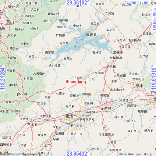
Shangfang GPS coordinates[2]
29° 16' 10.236" North, 118° 54' 57.816" East
| Map corner | latitude | longitude |
|---|---|---|
| Upper-left | 29.88102°, | 118.21294° |
| Center: | 29.26951°, | 118.91606° |
| Lower-right: | 28.65432°, | 119.61919° |
| Map W x H: | 136.4×136.4 km | = 84.8×84.8mi |
| max Lat: | 53.31946° ⇑62.4% North |
| Shangfang: | 29.26951° |
| min Lat: | ⇓37.6% South 18.22056° |
| min Long | Shangfang | max Long |
| 75.07348° | 118.91606° | 134.28917° |
| W 75.6%⇐ | ⇒24.4% E |
Elevation
Elevation of Shangfang is 188 m = 617 ft, and this is 296.8 m = 974 ft below average elevation for this country.
| Max E: |
5622 m = 18445 ft | 47.1% |
| Avg. | 484.8 m = 1591 ft | |
| Shangfang | 188 m = 617 ft | |
Min E: |
-3 m = -10 ft | 52.9% |
See also: China elevation on elevation.city.
Geographical zone
Shangfang is located in North temperate zone (between Tropic of Cancer and the Arctic Circle). Distance of this Northern Tropic circle is 648.5 km =403 mi to South.| Distance of | km | miles | from Shangfang |
|---|---|---|---|
| North Pole | 6752.6 | 4195.9 | to North |
| Arctic Circle | 4146.7 | 2576.6 | to North |
| Tropic Cancer | 648.5 | 403 | to South |
| Equator | 3254.5 | 2022.3 | to South |


Nearby cities:
15 places around Shangfang: (largest is in red/bold)
• Anyang
18.7 km =11.6 mi,  332°
332°
• Baima
19.6 km =12.2 mi,  261°
261°
• Datong
19.1 km =11.9 mi,  76°
76°
• Datou
20.1 km =12.5 mi,  229°
229°
• Duze
16.4 km =10.2 mi,  169°
169°
• Fengshuling
23.2 km =14.4 mi,  298°
298°
• Huipinggeng
6.4 km =4 mi,  249°
249°
• Lianhua
23.6 km =14.7 mi,  157°
157°
• Liyang
24.9 km =15.5 mi,  17°
17°
• Shangma
11.9 km =7.4 mi,  93°
93°
• Shifo
21.5 km =13.4 mi,  121°
121°
• Shuangqiao
15.4 km =9.6 mi,  191°
191°
• Xiacaoqiao
12.1 km =7.5 mi,  218°
218°
• Xiakou
15.5 km =9.6 mi,  153°
153°
• Zhoujia
22 km =13.7 mi,  182°
182°
Sources, notices
• [Note1] Compared only with cities in China existing in our database
• [Src1] Map data: © OpenStreetMap contributors (CC-BY-SA)
• [Src2] Other city data from geonames.org with taken over terms of usage.
• [Src3] Geographical zone / Annual Mean Temperature by Robert A. Rohde @ Wikipedia
