Beixiang geodata
Beixiang (Guangdong) is a seat of a fourth-order administrative division; located in China in Asia/Shanghai (GMT+8) time zone. In our database, there are 1268 cities with bigger population. Compared to other cities in China, 85.6% of cities are located further ↑North; 55.2% of cities are located further →East and 50.3% of cities have higher elevation than Beixiang. Note1


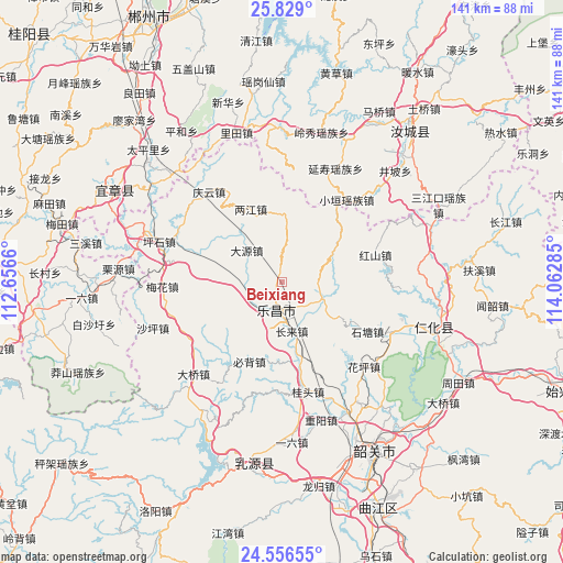
Beixiang GPS coordinates[2]
25° 11' 39.984" North, 113° 21' 34.992" East
| Map corner | latitude | longitude |
|---|---|---|
| Upper-left | 25.829°, | 112.6566° |
| Center: | 25.19444°, | 113.35972° |
| Lower-right: | 24.55655°, | 114.06285° |
| Map W x H: | 141.5×141.5 km | = 87.9×87.9mi |
| max Lat: | 53.31946° ⇑85.6% North |
| Beixiang: | 25.19444° |
| min Lat: | ⇓14.4% South 18.22056° |
| min Long | Beixiang | max Long |
| 75.07348° | 113.35972° | 134.28917° |
| W 44.8%⇐ | ⇒55.2% E |
Elevation
Elevation of Beixiang is 162 m = 531 ft, and this is 322.8 m = 1059 ft below average elevation for this country.
| Max E: |
5622 m = 18445 ft | 50.3% |
| Avg. | 484.8 m = 1591 ft | |
| Beixiang | 162 m = 531 ft | |
Min E: |
-3 m = -10 ft | 49.7% |
See also: China elevation on elevation.city.
Geographical zone
Beixiang is located in North temperate zone (between Tropic of Cancer and the Arctic Circle). Distance of this Northern Tropic circle is 195.4 km =121.4 mi to South.| Distance of | km | miles | from Beixiang |
|---|---|---|---|
| North Pole | 7205.7 | 4477.4 | to North |
| Arctic Circle | 4599.8 | 2858.2 | to North |
| Tropic Cancer | 195.4 | 121.4 | to South |
| Equator | 2801.4 | 1740.7 | to South |


Nearby cities:
15 places around Beixiang: (largest is in red/bold)
• Bibei
22.1 km =13.7 mi,  201°
201°
• Changlai
12.6 km =7.8 mi,  164°
164°
• Dayuan
11.5 km =7.1 mi,  320°
320°
• Hongshan
24.4 km =15.2 mi,  73°
73°
• Huaping
29.5 km =18.3 mi,  133°
133°
• Jiufeng
17.3 km =10.7 mi,  2°
2°
• Langtian
10.4 km =6.5 mi,  114°
114°
• Lecheng
7.4 km =4.6 mi,  187°
187°
• Liangjiang
20.7 km =12.9 mi,  343°
343°
• Meihua
28.9 km =18 mi,  266°
266°
• Qingyun
28.5 km =17.7 mi, 319°
• Shitang
24.8 km =15.4 mi,  122°
122°
• Wushan
13.7 km =8.5 mi,  62°
62°
• Youxi
26.4 km =16.4 mi,  179°
179°
• Yunyan
26.7 km =16.6 mi,  254°
254°
Sources, notices
• [Note1] Compared only with cities in China existing in our database
• [Src1] Map data: © OpenStreetMap contributors (CC-BY-SA)
• [Src2] Other city data from geonames.org with taken over terms of usage.
• [Src3] Geographical zone / Annual Mean Temperature by Robert A. Rohde @ Wikipedia
