Longgang geodata
Longgang (Zhejiang) is a seat of a fourth-order administrative division; located in China in Asia/Shanghai (GMT+8) time zone. In our database, there are 1268 cities with bigger population. Compared to other cities in China, 52.5% of cities are located further ↑North; 76.7% of cities are located further ←West and 51.8% of cities have higher elevation than Longgang. Note1


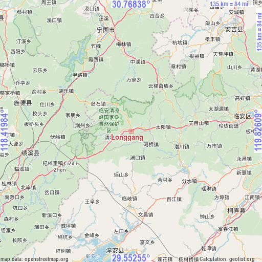
Longgang GPS coordinates[2]
30° 9' 44.424" North, 119° 7' 22.656" East
| Map corner | latitude | longitude |
|---|---|---|
| Upper-left | 30.76838°, | 118.41984° |
| Center: | 30.16234°, | 119.12296° |
| Lower-right: | 29.55255°, | 119.82609° |
| Map W x H: | 135.2×135.2 km | = 84×84mi |
| max Lat: | 53.31946° ⇑52.5% North |
| Longgang: | 30.16234° |
| min Lat: | ⇓47.5% South 18.22056° |
| min Long | Longgang | max Long |
| 75.07348° | 119.12296° | 134.28917° |
| W 76.7%⇐ | ⇒23.3% E |
Elevation
Elevation of Longgang is 151 m = 495 ft, and this is 333.8 m = 1095 ft below average elevation for this country.
| Max E: |
5622 m = 18445 ft | 51.8% |
| Avg. | 484.8 m = 1591 ft | |
| Longgang | 151 m = 495 ft | |
Min E: |
-3 m = -10 ft | 48.2% |
See also: China elevation on elevation.city.
Geographical zone
Longgang is located in North temperate zone (between Tropic of Cancer and the Arctic Circle). Distance of this Northern Tropic circle is 747.8 km =464.7 mi to South.| Distance of | km | miles | from Longgang |
|---|---|---|---|
| North Pole | 6653.3 | 4134.2 | to North |
| Arctic Circle | 4047.4 | 2514.9 | to North |
| Tropic Cancer | 747.8 | 464.7 | to South |
| Equator | 3353.7 | 2083.9 | to South |


Nearby cities:
15 places around Longgang: (largest is in red/bold)
• Changhua
9.1 km =5.7 mi,  85°
85°
• Daoshi
22.1 km =13.7 mi,  310°
310°
• Henglu
24.6 km =15.3 mi,  48°
48°
• Heqiao
12.2 km =7.6 mi,  122°
122°
• Jingzhou
25.3 km =15.7 mi,  277°
277°
• Maxiao
15.4 km =9.6 mi,  264°
264°
• Qianchuan
26.9 km =16.7 mi,  107°
107°
• Qingliangfeng
9.5 km =5.9 mi,  254°
254°
• Taiyang
16.8 km =10.4 mi,  81°
81°
• Tuankou
13.7 km =8.5 mi,  167°
167°
• Wanjia
26.9 km =16.7 mi,  2°
2°
• Xinqiao
20.8 km =12.9 mi,  298°
298°
• Yaoshan
22.7 km =14.1 mi,  193°
193°
• Yuqian
26.1 km =16.2 mi, 83°
• Yutiao
17.2 km =10.7 mi,  325°
325°
Sources, notices
• [Note1] Compared only with cities in China existing in our database
• [Src1] Map data: © OpenStreetMap contributors (CC-BY-SA)
• [Src2] Other city data from geonames.org with taken over terms of usage.
• [Src3] Geographical zone / Annual Mean Temperature by Robert A. Rohde @ Wikipedia
